
Images


September 8, 2021 - Post-flood Greening of the Taklamakan Desert
 Tweet
Tweet
The Taklamakan Desert is China’s biggest, hottest, and driest desert. Located in western China and filled with tall shifting-sand dunes, the desert stretches over an area measuring about 130,500 square miles (338,000 square km)—slightly larger than the state of New Mexico. Isolated from the Asian monsoon and from Arctic storms, the central basin receives less than 10 millimeters (0.4 inches) of precipitation per year. In such a parched environment, plants are rare, and yet they exist. When water comes to the parched land, vegetation begins to thrive.
Each year, usually in springtime, the heavy winter snows that top the surrounding mountains ranges begin to melt, creating runoff that fills the rivers that flow around and through the arid Taklamakan Desert. This process is usually predictable and gentle, with water coursing down from the mountains freely—enough to fill the dry riverbeds—but flooding is uncommon. In late July of this year, however, heavy precipitation in the Xinjiang region of western China, along with high temperatures that caused substantial glacial melt in the Tian Shan and Karakoram Mountains, combined to create spectacular flooding in the western edge of the Taklamakan Desert. The flooding lasted a few days, with the worst of the high water reported between July 26 and August 1. A month later, the drenching has led to a greening of the desert.
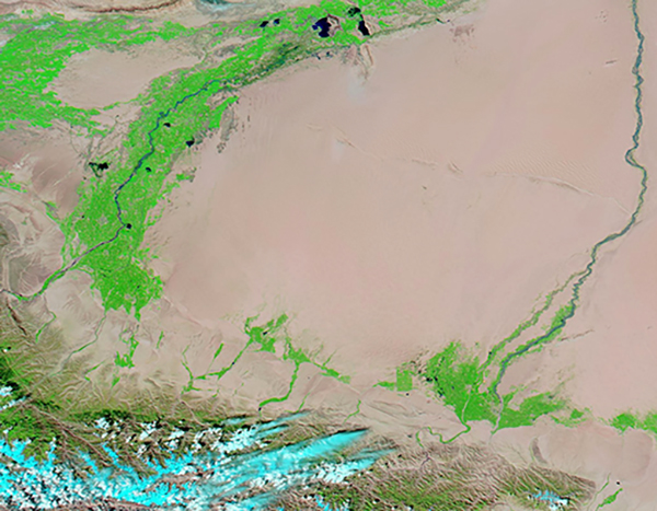
On September 3, 2021, the Moderate Resolution Imaging Spectroradiometer (MODIS) on board NASA’s Aqua satellite acquired a striking false-color image of the Taklamakan Desert. This type of image uses short-wave infrared, infrared, and red light (bands 7,2,1), to highlight vegetation and water. Vegetation appears electric green, water looks dark blue, open land appears in shades of tan, snow and ice looks bright blue, and cloud appears white. When clouds are cold and contain ice crystals, they will carry a tint of bright blue. In this image, it’s clear that copious vegetation covers the western edge of the Taklamakan, especially along the Yarkand River. The Yarkand River begins at the Rimo Glacier in the Karakoram Mountains.
While this one image gives substantial information regarding the extent of the post-flood greening of the desert, additional information can be gained by comparing this image, acquired September 3, with an additional Aqua MODIS false-color image acquired on February 12, well before the flood. Thanks to the NASA Worldview App, this comparison is simple. To see the difference a flood makes to the arid desert, click
HERE.
The NASA Worldview app provides a satellite's perspective of the planet as it looks today and as it has in the past through daily satellite images. Worldview is part of NASA’s Earth Observing System Data and Information System. EOSDIS makes the agency's large repository of data accessible and freely available to the public.
Image Facts
Satellite:
Aqua
Date Acquired: 9/3/2021
Resolutions:
1km (483.9 KB), 500m (1.2 MB), 250m (2.9 MB)
Bands Used: 7,2,1
Image Credit:
MODIS Land Rapid Response Team, NASA GSFC
The Taklamakan Desert is China’s biggest, hottest, and driest desert. Located in western China and filled with tall shifting-sand dunes, the desert stretches over an area measuring about 130,500 square miles (338,000 square km)—slightly larger than the state of New Mexico. Isolated from the Asian monsoon and from Arctic storms, the central basin receives less than 10 millimeters (0.4 inches) of precipitation per year. In such a parched environment, plants are rare, and yet they exist. When water comes to the parched land, vegetation begins to thrive.
Each year, usually in springtime, the heavy winter snows that top the surrounding mountains ranges begin to melt, creating runoff that fills the rivers that flow around and through the arid Taklamakan Desert. This process is usually predictable and gentle, with water coursing down from the mountains freely—enough to fill the dry riverbeds—but flooding is uncommon. In late July of this year, however, heavy precipitation in the Xinjiang region of western China, along with high temperatures that caused substantial glacial melt in the Tian Shan and Karakoram Mountains, combined to create spectacular flooding in the western edge of the Taklamakan Desert. The flooding lasted a few days, with the worst of the high water reported between July 26 and August 1. A month later, the drenching has led to a greening of the desert.
On September 3, 2021, the Moderate Resolution Imaging Spectroradiometer (MODIS) on board NASA’s Aqua satellite acquired a striking false-color image of the Taklamakan Desert. This type of image uses short-wave infrared, infrared, and red light (bands 7,2,1), to highlight vegetation and water. Vegetation appears electric green, water looks dark blue, open land appears in shades of tan, snow and ice looks bright blue, and cloud appears white. When clouds are cold and contain ice crystals, they will carry a tint of bright blue. In this image, it’s clear that copious vegetation covers the western edge of the Taklamakan, especially along the Yarkand River. The Yarkand River begins at the Rimo Glacier in the Karakoram Mountains.
While this one image gives substantial information regarding the extent of the post-flood greening of the desert, additional information can be gained by comparing this image, acquired September 3, with an additional Aqua MODIS false-color image acquired on February 12, well before the flood. Thanks to the NASA Worldview App, this comparison is simple. To see the difference a flood makes to the arid desert, click HERE.
The NASA Worldview app provides a satellite's perspective of the planet as it looks today and as it has in the past through daily satellite images. Worldview is part of NASA’s Earth Observing System Data and Information System. EOSDIS makes the agency's large repository of data accessible and freely available to the public.
Image Facts
Satellite:
Aqua
Date Acquired: 9/3/2021
Resolutions:
1km (483.9 KB), 500m (1.2 MB), 250m (2.9 MB)
Bands Used: 7,2,1
Image Credit:
MODIS Land Rapid Response Team, NASA GSFC
