
Images


March 5, 2022 - Tropical Cyclone Vernon
 Tweet
Tweet
After forming near the Cocos Islands on February 24, Tropical Cyclone Vernon experienced explosive intensification, increasing wind speeds by 80 mph (128.7 km/h) in 24 hours to reach Category 4 on the Saffir Simpson Hurricane Wind Scale on February 26. On that day maximum sustained winds reached 130 mph (209 km/h). Fortunately, the violent storm was spinning well away from land at that time. Since that time, Tropical Cyclone Vernon has drifted over the Indian Ocean as it continually weakened, posing no threat to land.
The Moderate Resolution Imaging Spectroradiometer (MODIS) on board NASA’s Terra satellite acquired a true-color image of Tropical Cyclone Vernon on March 3. Near the time this image was acquired, the waning storm carried maximum sustained winds of about 60 mph (96.6 km/h). Vernon retained a large cloud-filled eye but appeared strongly asymmetric, with convective bands south of center. By the evening of March 3, Vernon had become extra-tropical, and winds had dropped to about 45 mph (72 km/h).
Image Facts
Satellite:
Terra
Date Acquired: 3/3/2022
Resolutions:
1km (440.5 KB), 500m (1.2 MB), 250m (4.1 MB)
Bands Used: 1,4,3
Image Credit:
MODIS Land Rapid Response Team, NASA GSFC
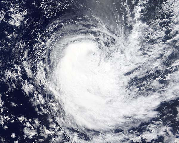
