Images
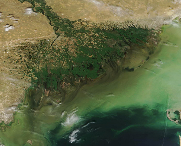
June 5, 2022 - Volga River Delta
Tweet
As the mighty Volga River—the largest river in Europe—meets the waters of the Caspian Sea, the rushing river slows dramatically, splitting into about 1,000 tangled channels and spreading out over an area of more than 20,000 square kilometers (7,700 square miles) to create the largest delta in Europe. The Volga delta is also one of the lowest-lying large river deltas on Earth, sitting near 27 meters (88.5 feet) below sea level in the Caspian Depression. Part of the Volga Delta is actually submerged as much as 2.5 meters (8 feet) below the saline waters of the Caspian Sea. The complex structure creates a vast and unique ecosystem that, among other things, supports an amazing array of migratory and breeding bird species, including several threatened and endangered species.
On June 2, 2022, the Moderate Resolution Imaging Spectroradiometer (MODIS) on board NASA’s Terra satellite acquired a true-color image of the Volga River Delta. The many tangled, tree-like channels create an area of rich green near the edge of the waters of the Caspian Sea. Muddy streaks can be seen extending from the edge well offshore, where the tan mixes with green-tinted water of the Caspian Sea.
The green tint is likely a combination of sediment and phytoplankton. Sediment appears muddy tan when it floats near the surface, as can be seen in near-shore waters. As it sinks below the surface, the reflectivity changes and so does the color as seen from space. Sinking sediment appears various shades of green. Large quantities of phytoplankton, which are microscopic chlorophyl-containing organisms, can also impart shades of green to the surface of sea water.
Image Facts
Satellite:
Terra
Date Acquired: 6/2/2022
Resolutions:
1km (130.5 KB), 500m (330.9 KB), 250m (733.9 KB)
Bands Used: 1,4,3
Image Credit:
MODIS Land Rapid Response Team, NASA GSFC


