
Images


June 22, 2022 - Springtime in James Bay
 Tweet
Tweet
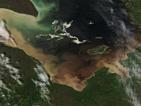
Remnants of sea ice floated on the frigid, sediment-and-tannin-stained waters of James Bay in late spring 2022. The Moderate Resolution Imaging Spectroradiometer (MODIS) on board NASA’s Aqua satellite acquired a true-color image of the colorful and dynamic transitional season on James Bay on June 19.
James Bay sits at the southernmost end of Hudson Bay, spanning about 135 miles (217 km) in width and 275 miles (443 km) in length. James Bay and its islands belong to Canada’s Nunavut province while the western shoreline belongs to Ontario and the lands to the east lie in Quebec. This relatively shallow bay typically freezes over before Hudson Bay in early winter, and often thaws earlier than those more northerly waters as well.
Many rivers flow into James Bay, most of them carrying heavy loads of mud-colored sediment stirred up as they flow through the muskeg that surrounds James Bay. Also known as bogland, organic terrain, or peatland, the flat, wet James Bay lowlands are found in abundance along the western side of the Bay and contain large amounts vegetation in various stages of decomposition, ranging from living moss to peat to decomposed muck. Muskeg tends to be very wet, both because the land is so low that the water table is near the surface, but also because some types of peat can hold 15 to 30 times as much water as its own weight. Such loose, wet soils easily lose sediment to the rivers that flow through them. In addition, peat soils release acidic tannins that stain water dark brown. When rain and spring snowmelt cause the muskeg to flood, huge amounts of tea-colored water and sediment pour into the James Bay.
In this image, green Akimiski Island can be seen in the upper left (northwest) corner and the smaller Charlton Island sits in the southeast end of James Bay, near the inflow of the large Nottaway River. Filigrees of sea ice float near the center of the Bay and white cloud casts shadow on the intensely-colored waters of James Bay near Akimiski Island. Cloud also covers parts of Ontario and Quebec.
Image Facts
Satellite:
Aqua
Date Acquired: 6/19/2022
Resolutions:
1km (138.1 KB), 500m (347.7 KB), 250m (215.2 KB)
Bands Used: 1,4,3
Image Credit:
MODIS Land Rapid Response Team, NASA GSFC
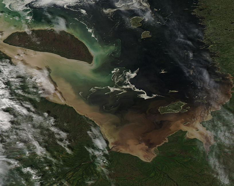
