Images
July 5, 2022 - Gravity Waves and Dust over the Red Sea
Tweet
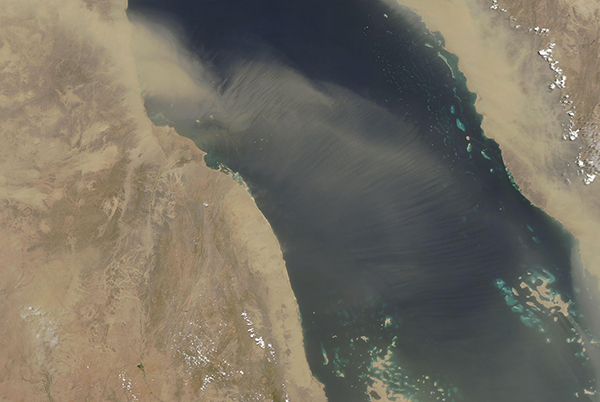
Throughout most of the month of June 2022, strong winds carried dust from the Sahara Desert over the Red Sea, sometimes creating a heavy blanket of airborne dust more than 1,000 km (620 mi) wide. On June 30, when the Moderate Resolution Imaging Spectroradiometer (MODIS) acquired a true-color image of the relentless storms, the dust had thinned. But it had also acquired a peculiar appearance, with many parallel lines stretching across most of the Red Sea dust.
These lines were most likely caused by gravity waves in the atmosphere, a type of turbulence caused by wind shear. As hot, dusty desert air move across the cooler, moist waters of the Red Sea, the lower layers of the air are slowed down, causing ripples in the atmosphere. These ripples are a lot like waves we can see moving across the surface of a lake—undulating up and down to create crests and troughs. The same motion often happens in the atmosphere, but waves can’t be seen when the air is clear. But when clouds are either cloudy or dusty, the gravity waves become visible. In this case, the motion of the air over the Red Sea is sorting the dust into bands as the atmosphere rolls along with the motion of the wind over the water.
Image Facts
Satellite:
Aqua
Date Acquired: 6/30/2022
Resolutions:
1km (257.5 KB), 500m (620.5 KB), 250m (303.8 KB)
Bands Used: 1,4,3
Image Credit:
MODIS Land Rapid Response Team, NASA GSFC


