
Images


August 2, 2022 - Smoke from Western Fires Stretch Across the United States
 Tweet
Tweet
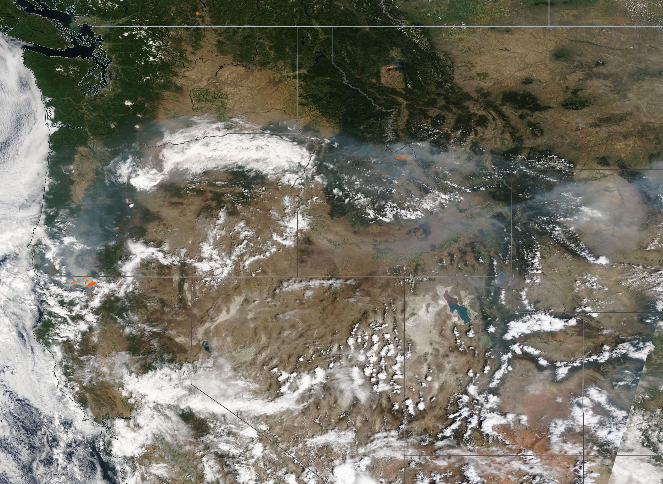
Smoke stretched from California’s Pacific Coast to Nebraska—a distance of nearly 2,000 km (1,243 mi)—in late July 2022. The Moderate Resolution Imaging Spectroradiometer (MODIS) on board NASA’s Terra satellite acquired this true-color image showing fire and smoke on July 23.
Each red “hot spot” marks a location where the thermal bands on the MODIS instrument detected high temperatures. When combined with typical smoke, as in this image, such hot spots are diagnostic for actively burning fire. Large fires are visible in Northern California, near the Oregon border as well as Idaho and Montana.
Long periods of high temperatures, low humidity, and gusty winds, along with acres of trees killed by pine beetles and long-standing drought has left some areas of the Western United States at high risk for wildfire. According to InciWeb Incident Information System, on August 1 there were 6 large active fires in New Mexico, 16 in Arizona, 4 in Utah, 3 in Colorado (two of these are prescribed burns), 2 in Wyoming, 4 in Nevada, 7 in Idaho, 5 in Montana, 1 in Washington, and 5 in California. CALFIRE identified an additional four fires in California. InciWeb does not report fires managed only by CALFIRE. It is important to note that the reported fires are only large or notable fires, and there are other smaller blazes in several locations.
The McKinney Fire, sitting near the border with Oregon, is contributing a large amount of smoke to the scene. This wildfire was first reported on the afternoon of July 29, 2022, on the Oak Knoll Ranger District of the Klamath National Forest. Despite a robust and rapid response, the fire quickly exploded in intensity, reaching 55,493 acres burnt by the evening of August 1. The McKinney Fire was cooled a bit on the night of July 31, thanks to rainfall. Unfortunately, the rain was spotty, with heavy rain in some areas to zero precipitation in other areas. Air temperatures had dropped a bit on August 1, and relative humidity was slightly higher, helping to moderate fire behavior. However, a Red Flag watch for extreme fire risk remains in place. The McKinney Fire is zero percent contained as of August 1, with no estimated containment date reported.
A second fire is also burning in Klamath National Forest, close to the McKinney Fire. It was sparked on July 29 by lightning strike and has grown to 1,989 acres as of August 1. It is also zero percent contained.
In its August 1 report on the McKinney and China Fires, the US Forest Service notes, “There have been numerous lightning strikes in the area in the last 48 hours, and at least 12 holdover fires have been detected on the Klamath National Forest, in addition to the ones listed above. They range in size from 1/10 acre to several acres. All are being fully suppressed.”
Image Facts
Satellite:
Terra
Date Acquired: 7/31/2022
Resolutions:
1km (616.5 KB), 500m (2.1 MB), 250m ( B)
Bands Used: 1,4,3
Image Credit:
MODIS Land Rapid Response Team, NASA GSFC
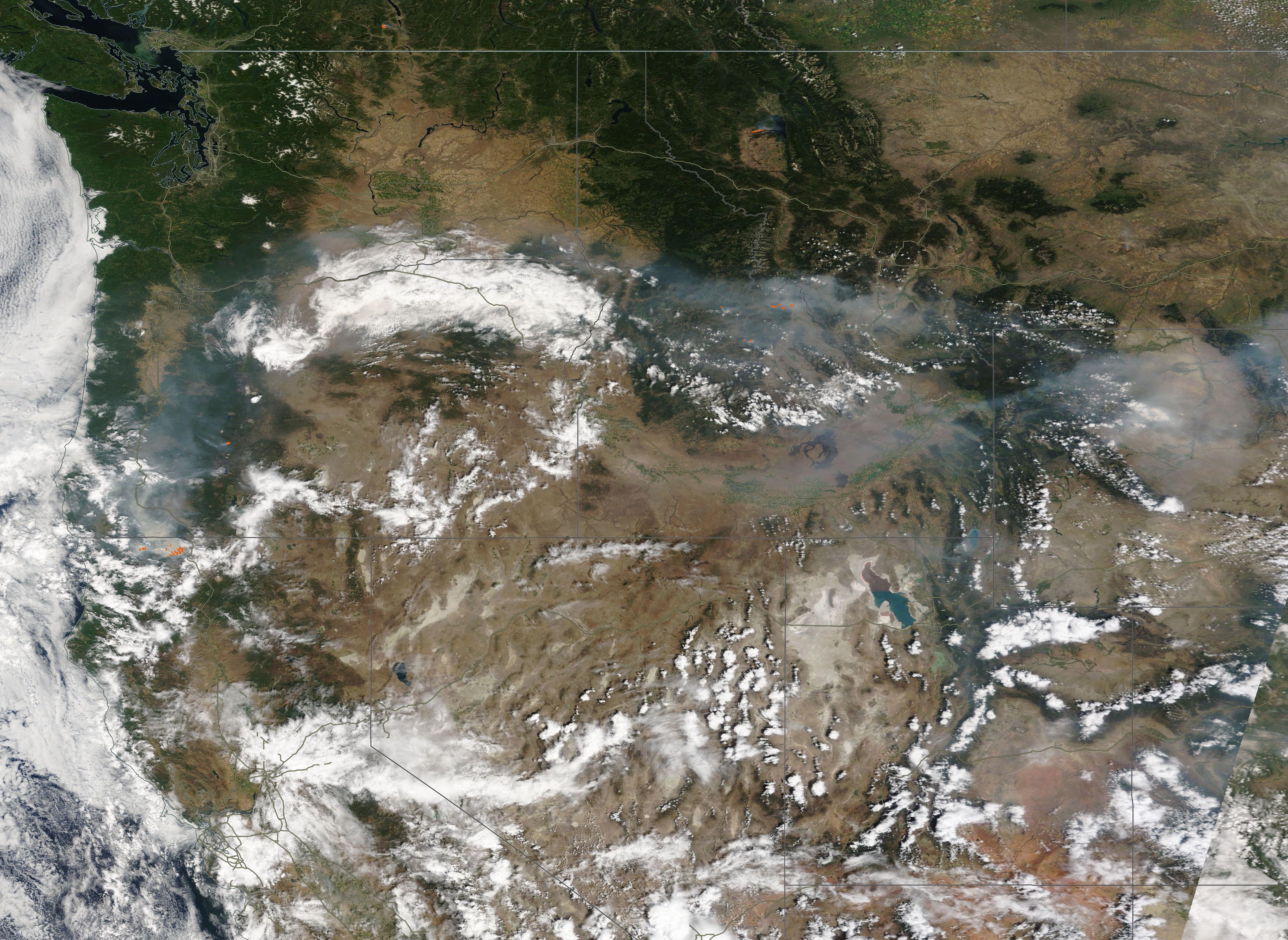
