
Images


February 13, 2025 - Multiple Winter Storms Pummel the United States
 Tweet
Tweet
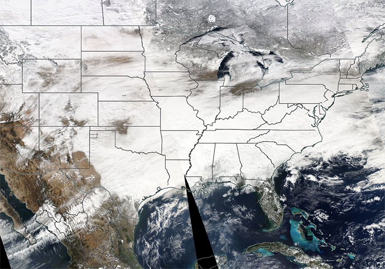
An exceptionally active weather pattern brought a “February Frenzy” of winter storms impacting much of the United States in 2025. On February 11, when the Moderate Resolution Imaging Spectroradiometer (MODIS) on NASA’s Terra satellite acquired this true-color image, storm clouds and snow stretched from the Rocky Mountains in the west to the Atlantic Coast of New England in the east.
Leading the string of dramatic frigid storms in 2025, a dip in the jet stream brought historically cold temperatures and snowfall to parts of the Southeast in late January. According to the National Oceanic and Atmospheric Administration (NOAA), on January 22, Baton Rouge, Louisiana, made it to 7°F (-13.9°C), which is the airport’s coldest temperature since records began in 1930. New Iberia, Louisiana recorded a low of 2°F (-16.7°C),the coldest temperature ever recorded at that site. Several states recorded highest-ever snow totals. This included Beaumont-Port Arthur, Texas with 4.5 inches (11.4 cm), Baton Rouge, Louisiana with 7.6 inches (19.3 cm) and New Orleans, Louisiana with 8.0 inches (20.3 cm).
By the opening days of February, the first of the February Frenzy storms, with a storm dubbed “Winter Storm Freya” by The Weather Channel dumping ice and snow from the Midwest to the Northeast by February 6. A second storm, dubbed Winter Storm Garnett, was close behind, starting in the Great Plains on February 7 and moving through the Northeast through February 11. Winter Storm Harlow began on February 10, with freezing rain and ice from Oklahoma to the Ozarks, according to The Weather Channel. The fast-moving storm then dumped more than 8 inches (20.3 cm) in parts of West Virginia, Maryland, and Washington, D. C. by February 11.
By February 11, the next storm, Winter Storm Iliana was already impacting 20 states. Iliana brought declarations of states of emergency in Missouri and Kansas, and shuttered schools in several states. Montana received as much as 3 inches (7.6 cm) and Kansas, southern Nebraska, and Iowa reported up to 6 inches (15.2 cm). In Virginia, about 180,000 homes were without power due to the storm, according to The Weather Channel. Storm names are not officially recognized by government weather services, but can be useful when discussing systems as they impact the United States.
Image Facts
Satellite:
Terra
Date Acquired: 2/11/2025
Resolutions:
1km (3.3 MB), 500m ( B), 250m ( B)
Bands Used: 1,4,3
Image Credit:
MODIS Land Rapid Response Team, NASA GSFC
