
Images


August 7, 2022 - Cow Canyon and Vantage Highway Fires
 Tweet
Tweet
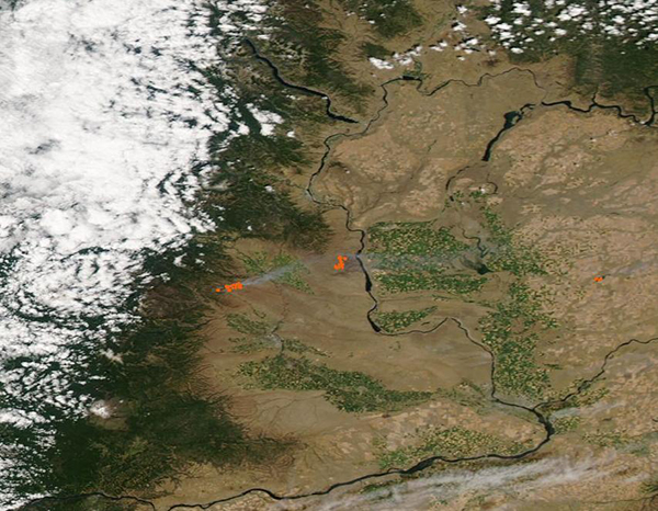
The 2022 wildfire season has heated up in the Pacific Northwest, with dozens of new fires popping up in Washington and Oregon in early August 2022. On August 6, the Washington Department of Natural Resources Wildfire Intel Dashboard reported that 5 large fires were ablaze in the state on that date, with 23 new ignitions in the last 24 hours. They also verified that 16,098 acres had been burnt in the last 24 hours alone.
On August 4, the Moderate Resolution Imaging Spectroradiometer (MODIS) on board NASA’s Aqua satellite acquired a true-color image of two of the largest fires burning in Washington. The Cow Canyon Fire sits west of the Vantage Highway Fire. Red “hot spots” mark areas where the thermal bands on the instrument detected high temperatures. When combined with typical smoke, as in this image, such hot spots are diagnostic of actively burning fire.
The Cow Canyon Fire was reported on the afternoon of August 3 approximately 1 mile northeast of Wenas, Washington. It exhibited a high rate of spread, burning rapidly through grass, brush, and timber. The rapid growth is well-illustrated by the large hot spot revealed by MODIS roughly 24 hours after ignition in this image. On August 5, the fire had expanded to cover 5,600 acres. Two primary residences, one cabin and eleven out buildings were confirmed destroyed on August 3. At least 50 additional structures are at risk and evacuation orders are in place in several locations. The fire is 45 percent contained on August 5, and the cause of ignition is still unknown.
The Vantage Highway Fire started on August 1, 2022, during a Red Flag warning, which brought high temperatures, very low humidity, and strong winds—all conducive to extreme fire behavior. It was originally reported five miles west of Vantage, a small town in Kittitas County, Washington. On August 6, the Vantage Highway Fire had burned 30,021 acres and firefighters had reached 45 percent containment. According to a report published in InciWeb Incident Information System on August 6, priorities remain full suppression of the fire, providing for firefighter and public safety, and protecting critical infrastructure (windfarms, residences) as well as sensitive cultural and natural resources such as the Thompson's clover, Chelan Rockmat, and critical mule deer habitat.
Image Facts
Satellite:
Aqua
Date Acquired: 8/4/2022
Resolutions:
1km (32.4 KB), 500m (109.2 KB), 250m (328.8 KB)
Bands Used: 1,4,3
Image Credit:
MODIS Land Rapid Response Team, NASA GSFC
