
Images


August 13, 2022 - Southeastern Brazil
 Tweet
Tweet
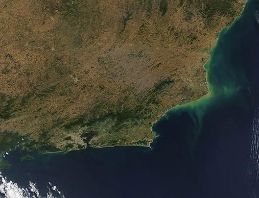
Forested highlands, long coastlines, and the metropolitan are of Rio de Janeiro dominate the landscape of southeastern Brazil. The Moderate Resolution Imaging Spectroradiometer (MODIS) acquired a true-color image of the states of Rio de Janeiro, Espiritu Santo, and the part of eastern Minas Gerais.
A large swatch of brown-gray pixels marks the city of Rio de Janeiro, the second-largest city in Brazil and home to about 13,634,000 people. The city’s full name is Cidade de São Sebastião do Rio de Janeiro, which translates as “City of Saint Sebastian of River of January”—but it normally goes by the popular nickname of, simply, Rio. The location on the west shore of Guanabara bay led the Portuguese explorers who explored the area in January, 1502, to think they had found the mouth of an amazing river, and this led to the name “River of January”.
The land north of Rio is dominated by highlands and rolling hills leading to the Espinhaço Mountains. At one time, several hundred years ago, the hills along the Atlantic coastal region were covered in tropical forest. Today, the ancient Atlantic Forest is only a fragmented patchwork of undisturbed forest, cut by highways, farms, pastures, and cities. Efforts are underway to replant some of the forested area. Remnant Atlantic Forest, along with newly regenerated forest appears dark green.
Much of southeastern Brazil’s coastlines are line by white sand beaches, which are alluring to tourists as well as vacationing locals. Two world-famous beaches include Copacabana, which sits on the first scallop of coastline on the western shore of Guanabara Bay and Ipanema, which sits on the Atlantic Ocean just west of Guanabara Bay in south zone of the city of Rio.
Image Facts
Satellite:
Terra
Date Acquired: 8/5/2022
Resolutions:
1km (222.4 KB), 500m (599.9 KB), 250m (393.6 KB)
Bands Used: 1,4,3
Image Credit:
MODIS Land Rapid Response Team, NASA GSFC
