
Images


November 5, 2022 - Autumn Colors in the Bay of Fundy
 Tweet
Tweet
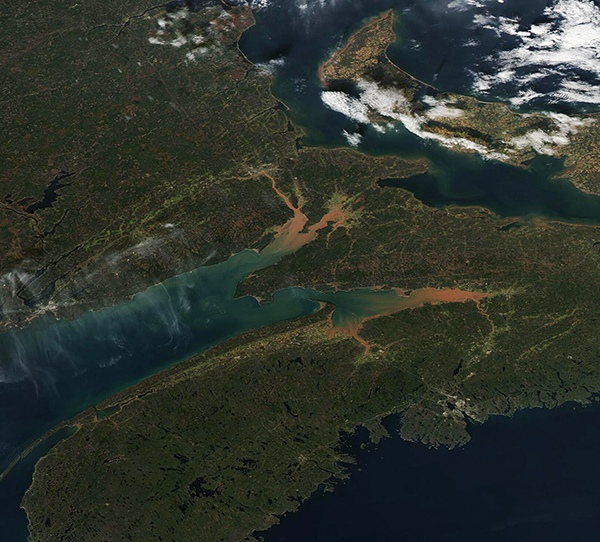
Bright sediment and flashy fall foliage greeted NASA’s Aqua satellite as it crossed the Bay of Fundy on November 3, 2022. The Moderate Resolution Imaging Spectroradiometer (MODIS) on board Aqua acquired a stunning true-color image of the scene on that same day.
The mount of the Bay of Fundy opens off the northeast coast of the state of Maine. It stretches 270 km (170 miles) northeast, separating the Canadian provinces of New Brunswick and Nova Scotia. The Bay is bordered stunning physical features, including fossil-filled rock cliffs, green marshland, and sandstone statues that jut upward and are topped by vegetation. Thick mudflats are common, especially in the upper Bay, and provide a rich source of suspended sediment.
The Bay of Fundy is a rich marine ecosystem, providing a home for species such as dolphin, porpoise, fish, seals, seabirds, and twelve species of whales. Both deciduous and evergreen trees fill the surrounding forests, creating a patchwork of green and glowing autumn leaves in the fall. There’s even a massive whirlpool reliably kicked up by tidal action off the coast of Maine.
The chocolate-colored rivers that flow into the Bay of Fundy pick up sediment far upstream as they pass through soft, red, and easily-eroded Triassic-era sandstone of northeastern Canada. In addition, the Bay’s spectacular tidal action—it has the highest observed tides on Earth—helps keep the Bay waters and incoming rivers muddy by churning mudflats. At the head of the Bay, in the Minas Basin (lower one in this image), the height of the tide can reach 16 meters (53 feet). By comparison, most of the coast of the United States has a tidal range of 1-2 meters (3-6 feet).
Image Facts
Satellite:
Aqua
Date Acquired: 11/3/2022
Resolutions:
1km (158.8 KB), 500m (422 KB), 250m (928.1 KB)
Bands Used: 1,4,3
Image Credit:
MODIS Land Rapid Response Team, NASA GSFC
