
Images


November 24, 2022 - North Carolina's Coastal Plain
 Tweet
Tweet
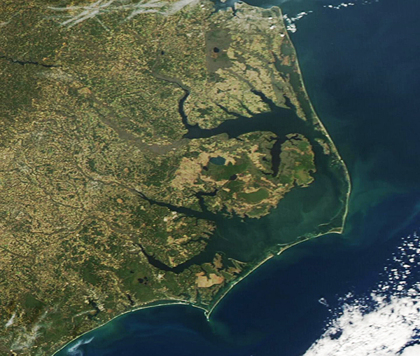
Skies were clear over eastern North Carolina on November 19, 2022, when the Moderate Resolution Imaging Spectroradiometer (MODIS) on board NASA’s Aqua satellite acquired a true-color image of a quiet autumn day in the region.
North Carolina is divided into three physical regions, each with characteristic landforms, soil types, and plant and animal inhabitants. From the west to the east, these regions are the Mountains, the Piedmont, and the Coastal Plain. The Coastal Plain, which is the region captured in this image, can also be divided into the Inner and Outer Coastal Plain. The Coastal Plain covers about 45 percent of North Carolina, rising steadily from the Atlantic Ocean and stretching roughly to I-95 as it traverses the state near the “fall line”—a relatively sharp rise in land along which waterfalls frequently form and which serves as the border between the Coastal Plain and the Piedmont.
The soils of the Inner Coastal Plain are rich, sandy, and famously fertile land for agricultural use. In autumn, farm fields often appear tan as crops are harvested and remaining stubble dries. Other fields may be planted with fast-growing cover crops, which appear green. The patchwork of yellows, tans, and greens seen inland is typical of agricultural fields in the fall.
The Outer Coastal Plain is sometimes divided into two additional regions: Tidewater and Outer Banks. The Tidewater sits behind the Barrier Islands and around the sounds and rivers, including Albemarle Sound (north) and Pamlico Sound (southeast) and the Neuse and Pamlico Rivers. This region lies near sea level and is filled with abundant wetlands, which are rich in biodiversity. The Tidewater is the only location on Earth where the Venus Flytrap plant grows naturally.
The barrier islands are a thin strip of land that sit between the Tidewater and the Atlantic Ocean. As a group, they are known as the Outer Banks and may be abbreviated as OBX. They were created by ocean currents in a rising sea that deposited swaths of sand off the coast. While they are considered stable enough to build on, the barrier islands are in constant flux from the work of waves and storms. It’s not uncommon for strong storms to cut new inlets—sometimes taking out part of the main road, NC 12, that connects most of the islands and permits year-round access for homeowners. It has been estimated that the state has spent 80 million dollars in the last decade to maintain NC 12, thanks to storm damage and the relentless shifting of the barrier island sand.
Image Facts
Satellite:
Aqua
Date Acquired: 11/19/2022
Resolutions:
1km (122.8 KB), 500m (318.5 KB), 250m (821 KB)
Bands Used: 1,4,3
Image Credit:
MODIS Land Rapid Response Team, NASA GSFC
