
Images


December 9, 2022 - Fires and Smoke in Western Africa
 Tweet
Tweet
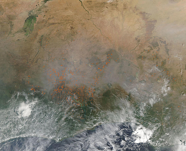
Hundreds of fires were burning across Western Africa in early December 2022. The Moderate Resolution Imaging Spectroradiometer (MODIS) on board NASA’s Aqua satellite acquired a true-colored image of clouds, smoke, and fire across several countries lying on the coast of Guinea on December 7.
Each red “hot spot” marks an area where the thermal bands on the MODIS instrument detected high temperatures typical of actively burning fire. The largest cluster of fires lie in Ghana, a country slightly smaller than the size of the U.S. state of Oregon. Fire also can be seen in Cote d'Ivoire, to the west of Ghana, as well as Togo and Benin, two countries to the east of Ghana. Further west, few fires are visible in Nigeria. few fires are also seen in Burkina Faso, in the northwest or Niger, located in the northeast. A smokey haze covers the landscape over the visible hot spots and northward, while clouds likely obscure many hot spots from view.
While it is not possible to discern the cause of a fire from satellite imagery, the time of year, location, and number of the fires strongly suggest that these fires are agricultural in origin. Most farmers in Ghana and nearby countries have small holding and still use traditional practices, such as fire, to manage land. Fires are used to clear stubble from old crops, to renew pasture, to open new land for cropping or pasture, or to prepare for planting.
Image Facts
Satellite:
Aqua
Date Acquired: 12/7/2022
Resolutions:
1km (361.8 KB), 500m (1.2 MB), 250m (4 MB)
Bands Used: 1,4,3
Image Credit:
MODIS Land Rapid Response Team, NASA GSFC
