
Images


December 14, 2022 - Massive Winter Storm Rolls Across the United States
 Tweet
Tweet
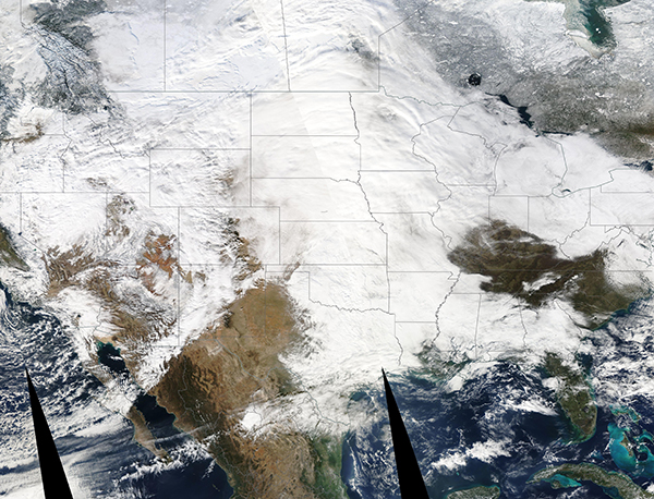
A massive, major winter storm was sweeping across the United States on December 12, 2022, when the Moderate Resolution Imaging Spectroradiometer (MODIS) on board NASA’s Aqua satellite captured this true-color image.
At the time the image was acquired, the most active line of the storm stretched from the southern tip of the U.S. state of Texas northward to Manitoba, Canada.
Almost all of the area under heavy cloud cover were experiencing active winter weather. Heavy snowfall and strong winds were pummeling the Northern Plains and Midwest, with some areas reporting blizzard conditions and winds up to 60 mph. Ice and intense snowfall shut down portions of several interstates for hours. Further south, destructive tornadoes popped up across Texas, Oklahoma, and Louisiana, while Arkansas, and Mississippi residents were under tornado watches and warnings. According to the Washington Post, as of December 13, about 10 million people from the Rockies to the northern Great Lakes were under some kind of winter weather alert.
Not only is active weather stretching from north to south across the entire United States, it will also roll across the country from west to east. The first volleys of this system began to affect the U.S. West Coast on December 9, according to the National Weather Service. By December 11, parts of California’s Sierra Nevada Mountains had accumulated more than five feet of fresh snowfall. The Utah Avalanche Center noted increasing risks in the backcountry of the Wasatch Ranges, with all locations at either “Considerable” or “High” risk.
The system will continue to roll across the United States, reaching parts of the Mid-Atlantic and Northeast on December 14. While northerly locations can expect heavy snow and wind, the National Weather Service advises that the storm will bring freezing rain and sleet along with gusting wind to parts of Virginia and Maryland, which is likely to trigger power outages and downed trees. Ice accumulation of up to 0.5 inches (1.3 cm) is expected in Oakland, a mountain town in western Maryland, with up to one-tenth of an inch (0.25 cm) in Baltimore, Maryland.
Image Facts
Satellite:
Aqua
Date Acquired: 12/12/2022
Resolutions:
1km (3.4 MB),
Bands Used: 1,4,3
Image Credit:
MODIS Land Rapid Response Team, NASA GSFC
A massive, major winter storm was sweeping across the United States on December 12, 2022, when the Moderate Resolution Imaging Spectroradiometer (MODIS) on board NASA’s Aqua satellite captured this true-color image. At the time the image was acquired, the most active line of the storm stretched from the southern tip of the U.S. state of Texas northward to Manitoba, Canada.
Almost all of the area under heavy cloud cover were experiencing active winter weather. Heavy snowfall and strong winds were pummeling the Northern Plains and Midwest, with some areas reporting blizzard conditions and winds up to 60 mph. Ice and intense snowfall shut down portions of several interstates for hours. Further south, destructive tornadoes popped up across Texas, Oklahoma, and Louisiana, while Arkansas, and Mississippi residents were under tornado watches and warnings. According to the Washington Post, as of December 13, about 10 million people from the Rockies to the northern Great Lakes were under some kind of winter weather alert.
Not only is active weather stretching from north to south across the entire United States, it will also roll across the country from west to east. The first volleys of this system began to affect the U.S. West Coast on December 9, according to the National Weather Service. By December 11, parts of California’s Sierra Nevada Mountains had accumulated more than five feet of fresh snowfall. The Utah Avalanche Center noted increasing risks in the backcountry of the Wasatch Ranges, with all locations at either “Considerable” or “High” risk.
The system will continue to roll across the United States, reaching parts of the Mid-Atlantic and Northeast on December 14. While northerly locations can expect heavy snow and wind, the National Weather Service advises that the storm will bring freezing rain and sleet along with gusting wind to parts of Virginia and Maryland, which is likely to trigger power outages and downed trees. Ice accumulation of up to 0.5 inches (1.3 cm) is expected in Oakland, a mountain town in western Maryland, with up to one-tenth of an inch (0.25 cm) in Baltimore, Maryland.
Image Facts
Satellite:
Aqua
Date Acquired: 12/12/2022
Resolutions:
1km (3.4 MB),
Bands Used: 1,4,3
Image Credit:
MODIS Land Rapid Response Team, NASA GSFC
