
Images


January 26, 2023 - Tropical Cyclone Cheneso Intensifies in the Mozambique Channel
 Tweet
Tweet
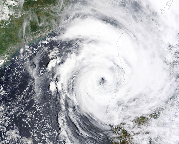
After significantly weakening as it crossed northern Madagascar after it made landfall on January 19, 2023, Tropical Cyclone Cheneso quickly restrengthened after popping out over the Mozambique Channel on January 23.
The Moderate Resolution Imaging Spectroradiometer (MODIS) on board NASA’s Terra satellite acquired a true-color image of the regenerating storm on January 25, less than two days after Cheneso moved off land. At that time, the system sported a large, nearly cloud-free eye and large convective bands that continued to dump heavy rain on badly-flooded Madagascar.
Tropical Cheneso initially made landfall on the northern coast of Madagascar on the morning of January 19, carrying maximum sustained winds of about 66 mph (106 km/h). Wind speeds quickly dropped as it moved southwest over the island, reaching 20 mph (32 km/h) on January 21 and remaining near these speeds before the storm moved over the Mozambique Channel. On January 25, less than 48 hours after leaving land, Cheneso’s maximum sustained winds had reached 85 mph (137 km/h).
According to the Joint Typhoon Warning Center (JTWC), maximum sustained winds are expected to peak at 115 mph (185 km/h) on January 27, bringing to the equivalent of a Category 3 storm on the Saffir-Simpson Hurricane Wind Scale. Fortunately, the center of Tropical Storm Cheneso is forecast to remain offshore, tracking southward down the Mozambique Channel and passing the southern tip of Madagascar before strong wind shear pushes it southwestward and out to the open Indian Ocean. However, most of the island will continue to be affected by the storm’s winds and rain, especially western and southern Madagascar.
While wind speeds were moderate as Cheneso crossed northern Madagascar, torrential rainfall created significant damage. According to a report on ReliefWeb, as of January 25 seven people have died and thirteen others are missing. Approximately 14,400 individuals have been displaced to temporary shelters. Reports state that more than 10,500 homes have been damaged, along with about 100 classrooms. Widespread flooding and landslides have occurred, and in some areas have damaged or inundated roadways, cutting some communities off from services.
Image Facts
Satellite:
Terra
Date Acquired: 1/25/2023
Resolutions:
500m (3 MB), 250m (2.4 MB)
Bands Used: 1,4,3
Image Credit:
MODIS Land Rapid Response Team, NASA GSFC
