
Images


April 5, 2023 - Gulf of Bothnia
 Tweet
Tweet
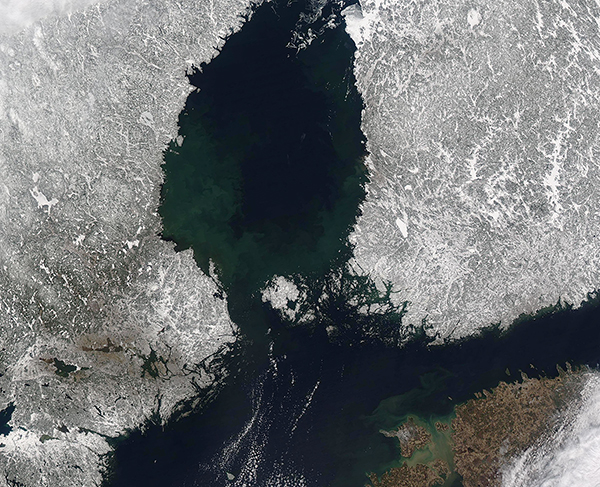
On April 3, 2023, the Moderate Resolution Imaging Spectroradiometer (MODIS) on board NASA’s Aqua satellite acquired a true-color image of the southern section of the Gulf of Bothnia.
The cloud-free skies allow an expansive view of the dark waters bounded by the snow-covered landscape of Sweden (west) and Finland (east). In the south, the Aland Islands sit at the boundary of the Gulf and the Baltic Sea. The Aland Islands, which belong to Finland, consist of about 35 inhabited islands, more than 6,000 uninhabited islands and rocky reefs. The largest island, Fasta Aland, contains about 70 percent of the total land mass of the archipelago.
The northern section of the Gulf of Bothnia, also called the Bothnian Bay, sits out of sight and to the north of this image. It is shallow, with an average depth of about 42 meters (138 feet). The southern section, called the Bothnian Sea, is deeper, dropping to a maximum depth of 294 meters (965 feet). At this time of year, the northern section of the Gulf remains covered with ice, while the southern section (also called the Bothnian Sea) appears almost entirely ice free, with the exception of a small amount of fast ice which can be seen clinging to the coast of Finland at the northern reach of the Bothnian Sea.
Image Facts
Satellite:
Aqua
Date Acquired: 4/3/2023
Resolutions:
1km (393.9 KB), 500m (1.2 MB), 250m (3.6 MB)
Bands Used: 1,4,3
Image Credit:
MODIS Land Rapid Response Team, NASA GSFC
