
Images


July 12, 2023 - More Wildfires Erupt in Western Canada
 Tweet
Tweet
Thanks to exceptionally dry and hot weather, the 2023 Canadian wildfire season—which normally runs from April to September—has been a record-maker.
According to media reports, in early July Canadian officials warned that the country was likely to face a “long, tough summer”—and that prediction seems to already be coming true. A brutal heatwave has gripped parts of the country, bringing temperatures of 100.2˚F (37.9˚C) to the community of Norman Wells, Northwest Territories (NWT) on July 9, which is the hottest temperature ever measured north of 65˚N latitude in the Western Hemisphere. It was just short of the record of 100.4˚F (38˚C) set at Verkhoyansk, Russia, a village at a similar latitude in June 2020. This is very close to the Arctic Circle, which sits at approximately 66.5˚N latitude.
The scorching temperatures across northwestern and western Canada have increased fire danger so much that the Canadian forests have nearly become little more than tinder-boxes just waiting for ignition. When storms rolled over western Canada on July 7 and 9, there were more than 23,000 lightning strikes recorded in British Columbia alone, and these sparked more than 200 new wildfires according to BC Wildfire Service. Because fuel moisture is a key component to how wildfires behave, the exceptionally dry vegetation means not only fast ignition but also increases the risk for rapid spread.
As of July 11, the Canadian Interagency Forest Fire Center (CIFFC) posted that there were 875 active fires burning across Canada, with 48 new starts in the last 24 hours. 533 of these were listed as “out of control”, with 128 “being held”, and 211 classified as “under control”. The largest number of fires were found in the west, with the most fires burning in British Columbia, with Alberta second. The province of Quebec, in eastern Canada, was in third place. The CIFFC also reported that there had been a total of 3,904 wildland fires since January 1, which is well above the average of 2,751. In the same time, 9.5 million hectares have burnt—an area slightly larger than the U.S. state of Indiana and well above the previous record of 7.89 million hectares burnt in 1989.
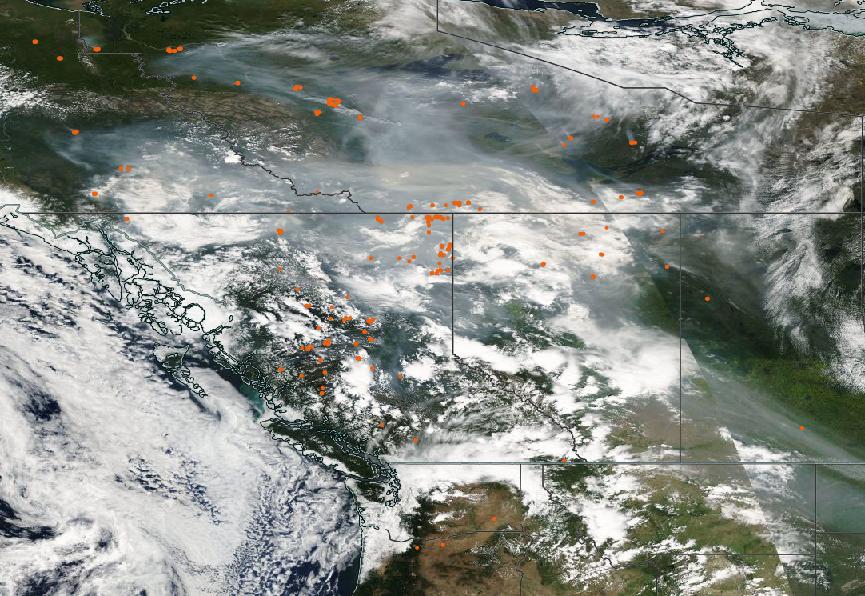
The Moderate Resolution Imaging Spectroradiometer (MODIS) on board NASA’s Aqua satellite acquired a true-color image of wildfires burning across Western Canada on July 10. Each red “hot spot” marks an area of heat from an actively burning fire. Provinces visible in this image, each containing active fires, include (moving from west to east) British Columbia (with the most fires), Alberta, and Saskatchewan. The northern tier includes Yukon and Northwest Territories. Dense smoke smothers much of the region, stretching from Canada’s far north to sweep over the U.S. states of Montana and North Dakota.
Image Facts
Satellite:
Aqua
Date Acquired: 7/10/2023
Resolutions:
1km (2.2 MB),
Bands Used: 1,4,3
Image Credit:
MODIS Land Rapid Response Team, NASA GSFC
Thanks to exceptionally dry and hot weather, the 2023 Canadian wildfire season—which normally runs from April to September—has been a record-maker.
According to media reports, in early July Canadian officials warned that the country was likely to face a “long, tough summer”—and that prediction seems to already be coming true. A brutal heatwave has gripped parts of the country, bringing temperatures of 100.2˚F (37.9˚C) to the community of Norman Wells, Northwest Territories (NWT) on July 9, which is the hottest temperature ever measured north of 65˚N latitude in the Western Hemisphere. It was just short of the record of 100.4˚F (38˚C) set at Verkhoyansk, Russia, a village at a similar latitude in June 2020. This is very close to the Arctic Circle, which sits at approximately 66.5˚N latitude.
The scorching temperatures across northwestern and western Canada have increased fire danger so much that the Canadian forests have nearly become little more than tinder-boxes just waiting for ignition. When storms rolled over western Canada on July 7 and 9, there were more than 23,000 lightning strikes recorded in British Columbia alone, and these sparked more than 200 new wildfires according to BC Wildfire Service. Because fuel moisture is a key component to how wildfires behave, the exceptionally dry vegetation means not only fast ignition but also increases the risk for rapid spread.
As of July 11, the Canadian Interagency Forest Fire Center (CIFFC) posted that there were 875 active fires burning across Canada, with 48 new starts in the last 24 hours. 533 of these were listed as “out of control”, with 128 “being held”, and 211 classified as “under control”. The largest number of fires were found in the west, with the most fires burning in British Columbia, with Alberta second. The province of Quebec, in eastern Canada, was in third place. The CIFFC also reported that there had been a total of 3,904 wildland fires since January 1, which is well above the average of 2,751. In the same time, 9.5 million hectares have burnt—an area slightly larger than the U.S. state of Indiana and well above the previous record of 7.89 million hectares burnt in 1989.
The Moderate Resolution Imaging Spectroradiometer (MODIS) on board NASA’s Aqua satellite acquired a true-color image of wildfires burning across Western Canada on July 10. Each red “hot spot” marks an area of heat from an actively burning fire. Provinces visible in this image, each containing active fires, include (moving from west to east) British Columbia (with the most fires), Alberta, and Saskatchewan. The northern tier includes Yukon and Northwest Territories. Dense smoke smothers much of the region, stretching from Canada’s far north to sweep over the U.S. states of Montana and North Dakota.
Image Facts
Satellite:
Aqua
Date Acquired: 7/10/2023
Resolutions:
1km (2.2 MB),
Bands Used: 1,4,3
Image Credit:
MODIS Land Rapid Response Team, NASA GSFC
