Images
August 8, 2024 - The Wandel Sea: The Last Ice Area
Tweet
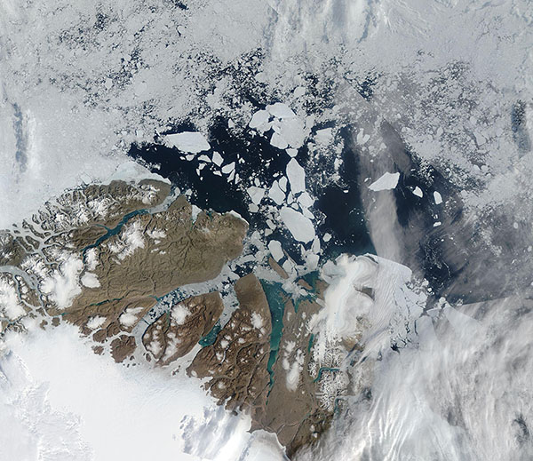
The Wandel Sea, which stretches from northeast Greenland to Svalbard, has been called the “Last Ice Area”, based on its thick, multi-year coating of year-round sea ice.
"This area has long been expected to be the primary refuge for ice-dependent species because it is one of the last places where we expect summer sea ice to survive in the Arctic," said Kristin Laidre, a scientist at the University of Washington Applied Physics Laboratory and co-author of a study of the region published in 2021 in Communications Earth & Environment. That study focused on August 2020 sea ice coverage on the Wandel Sea when satellite images showed extensive open water and a record low of just 50% sea ice concentration on August 14, 2020. The results, according to a story by the National Science Foundation, determined that about 80% was due to weather-related factors, like winds that break up and move the ice around. The other 20% was from the longer-term thinning of the sea ice due to global warming.
The Moderate Resolution Imaging Spectroradiometer (MODIS) on NASA’s Aqua satellite acquired this true-color image of the Wandel Sea on August 3, 2024. Sea ice still exists on the Sea, especially south of the islands within King Frederick VIII Land in the Northeast Greenland National Park. However, much of the ice in between the islands and north of them has melted, leaving open water evident. Icebergs and bergy bits (smaller chunks of floating ice) fill much of the Wangel Sea in the north.
On August 6, 2024, the National Snow and Ice Data Center published an update entitled “The chill is gone”. They noted that "Arctic sea ice cover retreated rapidly in July 2024, pushing the daily ice extent at the end of the month to the third lowest in the 46-year satellite record. Extensive low-concentration areas of sea ice are found in the Beaufort and East Siberian Seas, reaching 85 degrees North." They also stated,“In the Southern Ocean, sea ice is nearing the extreme low record extent set just last year, caused mostly by a large ice-free area in the southwestern Indian Ocean. As a result, global sea ice extent is at record lows for this time of year.”
Image Facts
Satellite:
Aqua
Date Acquired: 8/3/2024
Resolutions:
1km (397.4 KB), 500m (397.4 KB), 250m (1 MB)
Bands Used: 1,4,3
Image Credit:
MODIS Land Rapid Response Team, NASA GSFC


