
Images


April 11, 2024 - Total Solar Eclipse Darkens North America
 Tweet
Tweet
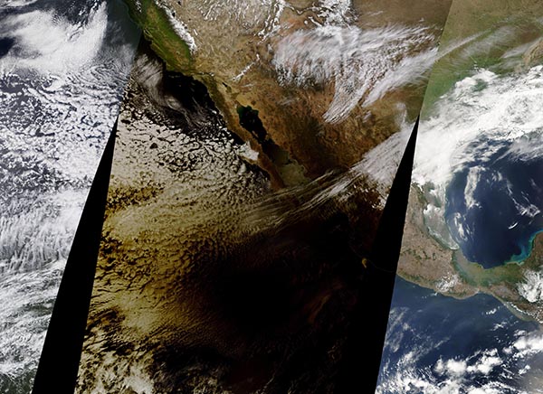
On April 8, 2024, millions of North Americans saw day turn temporarily to night as the Moon passed between the Sun and Earth to create a total solar eclipse.
As people in the 115-mile-wide (185-kilometer-wide) path of totality looked up and saw the Moon conceal the bright orb of the Sun and obscure all but its wispy corona, Earth-observing satellites captured imagery of the Moon’s shadow as it raced northeastward over North America. The track of the eclipse began on the Pacific coast of Mexico, then passed over Texas and parts of twelve additional U.S. states and six Canadian provinces before crossing off the coast of Newfoundland, Canada.
The Moderate Resolution Imaging Spectroradiometer (MODIS) on NASA’s Terra satellite acquired this true-color image of the eclipse as it began its sweep over North America. The image is a mosaic, created by stitching data from three passes of the satellite over the area; only the center image captures the rapidly moving eclipse. The black area over the Pacific Ocean and coastal Mexico is the umbra (lunar shadow), where light from the Sun is completely blocked by the Moon. The golden area is the penumbra, where viewers from Earth would see a partial eclipse.
Observers on the ground had a rare view of the Sun’s active outer atmosphere, or corona. Glowing loops of plasma called solar prominences could also be seen extending into the corona. Plasma is super-hot ionized gas which flows along the tangled and twisted structure of the Sun’s magnetic fields. Just before totality, birds began to sing as if it was twilight and then fell into silence during the height of the darkness, according to eye-witness reports on various social media. At the moment of totality, as the corona became visible, gasps and cheers erupted from viewers at various sites across the region.
The next total solar eclipse to travel across the lower 48 U.S. states from coast to coast will be in 2045.
Image Facts
Satellite:
Terra
Date Acquired: 4/8/2024
Resolutions:
1km (2.8 MB),
Bands Used: 1,4,3
Image Credit:
MODIS Land Rapid Response Team, NASA GSFC
