
Images


June 26, 2024 - Flooding in Iowa and South Dakota


June 24, 2024
June 10, 2024
Tweet
Over a foot of rain fell on parts of South Dakota and Iowa in late June 2024, sending water over riverbanks across the region. Overflowing rivers destroyed homes and bridges and inundated farm fields in several Midwestern states.
A front of dense moisture, drawn north from the Gulf of Mexico, parked over southeastern South Dakota and northwestern Iowa on June 20 and 21, unleashing torrential rainfall. Mitchell and Sioux Falls, South Dakota, recorded 6.5 and 7.7 inches of cumulative rain, respectively. It was the wettest two-day period for these cities in the National Weather Service’s (NWS) climate record, dating back to 1893. In Canton, South Dakota, near Iowa’s border, about 15 inches of rain fell on those days, according to NWS estimates.
The front brought rain to already saturated soils, according to the NWS National Water Center. The Great Plains region had already received 150–200 percent of its normal rainfall between mid-May and mid-June. Using soil moisture data from NASA’s Short-term Prediction Research and Transition (SPoRT) center, NWS forecasted that the ground may not be able to absorb more water.
The Big Sioux River, which runs along the Iowa-South Dakota border, rose to record heights after back-to-back days of heavy rainfall. On June 23, the level of the river in Sioux City, Iowa, reached almost 45 feet—7 feet higher than the previous record. That evening, a steel railroad bridge connecting North Sioux City, South Dakota, with Sioux City, Iowa, collapsed into the Big Sioux River.
In northwestern Iowa, about a foot of rain fell over two days near the town of Rock Valley, 50 miles (80 kilometers) southeast of Sioux Falls. Excessive rain filled the Rock River, bringing it to an all-time high of 27 feet (19 feet is the major flooding stage). The river broke a levee in Rock Valley on the morning of June 22, sending a torrent of floodwater across the town and forcing 4,000 residents to evacuate.
Next, the front passed over southern Minnesota and caused water levels to build along several rivers in the state. According to news reports, rising waters on the Blue Earth River washed out a portion of the Rapidan Dam, near Mankato.
As of June 25, the water levels of many rivers in this part of the Great Plains had begun to fall but were still in major flooding stage, according to the NWS.
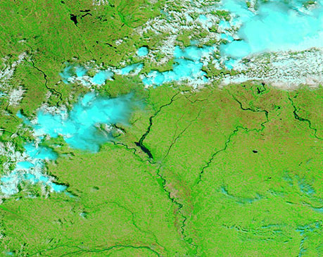
To assess the extent of flooding, today’s Image of the Day shows two false-color images of the region acquired the Moderate Resolution Imaging Spectroradiometer (MODIS) on NASA’s Aqua satellite. The first was acquired on June 24, 2024, and the second was acquired on June 10, 2024, shortly before the skies opened to unleash the torrential rain. This type of false-color image makes it easier to separate water (blue) from vegetation (bright green). Cloud usually appears white although high, cold clouds may be tinted with electric blue. To toggle between the images for comparison simply click on the date.
The most striking flooding is in the Big Sioux River, which has expanded to look like a wide lake just above where it flows into the Missouri River at Sioux City, Iowa. This flooding, along with notable prominence and widening of the Missouri and several other rivers, is clearly evident in the June 24 image. On June 10, the Big Sioux is barely visible.
Image Facts
Satellite:
Aqua
Date Acquired: 6/24/2024
Resolutions:
1km (114.1 KB), 500m (294.8 KB), 250m (458.2 KB)
Bands Used: 7,2,1
Image Credit:
MODIS Land Rapid Response Team, NASA GSFC
June 24, 2024 June 10, 2024
Over a foot of rain fell on parts of South Dakota and Iowa in late June 2024, sending water over riverbanks across the region. Overflowing rivers destroyed homes and bridges and inundated farm fields in several Midwestern states. A front of dense moisture, drawn north from the Gulf of Mexico, parked over southeastern South Dakota and northwestern Iowa on June 20 and 21, unleashing torrential rainfall. Mitchell and Sioux Falls, South Dakota, recorded 6.5 and 7.7 inches of cumulative rain, respectively. It was the wettest two-day period for these cities in the National Weather Service’s (NWS) climate record, dating back to 1893. In Canton, South Dakota, near Iowa’s border, about 15 inches of rain fell on those days, according to NWS estimates.
The front brought rain to already saturated soils, according to the NWS National Water Center. The Great Plains region had already received 150–200 percent of its normal rainfall between mid-May and mid-June. Using soil moisture data from NASA’s Short-term Prediction Research and Transition (SPoRT) center, NWS forecasted that the ground may not be able to absorb more water.
The Big Sioux River, which runs along the Iowa-South Dakota border, rose to record heights after back-to-back days of heavy rainfall. On June 23, the level of the river in Sioux City, Iowa, reached almost 45 feet—7 feet higher than the previous record. That evening, a steel railroad bridge connecting North Sioux City, South Dakota, with Sioux City, Iowa, collapsed into the Big Sioux River.
In northwestern Iowa, about a foot of rain fell over two days near the town of Rock Valley, 50 miles (80 kilometers) southeast of Sioux Falls. Excessive rain filled the Rock River, bringing it to an all-time high of 27 feet (19 feet is the major flooding stage). The river broke a levee in Rock Valley on the morning of June 22, sending a torrent of floodwater across the town and forcing 4,000 residents to evacuate.
Next, the front passed over southern Minnesota and caused water levels to build along several rivers in the state. According to news reports, rising waters on the Blue Earth River washed out a portion of the Rapidan Dam, near Mankato.
As of June 25, the water levels of many rivers in this part of the Great Plains had begun to fall but were still in major flooding stage, according to the NWS. To assess the extent of flooding, today’s Image of the Day shows two false-color images of the region acquired the Moderate Resolution Imaging Spectroradiometer (MODIS) on NASA’s Aqua satellite. The first was acquired on June 24, 2024, and the second was acquired on June 10, 2024, shortly before the skies opened to unleash the torrential rain. This type of false-color image makes it easier to separate water (blue) from vegetation (bright green). Cloud usually appears white although high, cold clouds may be tinted with electric blue. To toggle between the images for comparison simply click on the date.
The most striking flooding is in the Big Sioux River, which has expanded to look like a wide lake just above where it flows into the Missouri River at Sioux City, Iowa. This flooding, along with notable prominence and widening of the Missouri and several other rivers, is clearly evident in the June 24 image. On June 10, the Big Sioux is barely visible.
Image Facts
Satellite:
Aqua
Date Acquired: 6/24/2024
Resolutions:
1km (114.1 KB), 500m (294.8 KB), 250m (458.2 KB)
Bands Used: 7,2,1
Image Credit:
MODIS Land Rapid Response Team, NASA GSFC
