
Images


August 21, 2024 - South Africa's Western Cape
 Tweet
Tweet
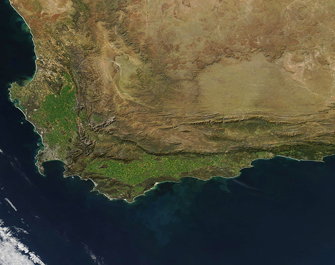
The Moderate Resolution Imaging Spectroradiometer (MODIS) on NASA’s Aqua satellite acquired a gorgeous true-color image of the southern tip of Africa on August 19, 2024.
The Western Cape region is the most southerly and the largest of the nine provinces of South Africa. It sweeps along the western and southern edge of the country, with coasts along the South Pacific Ocean (west) and the Indian Ocean (east). The most southerly point is Cape Agulhas, a rocky strip of land that marks the division point between the South Pacific and the Indian Oceans. The spot sits about 2,400 miles (3,800 km) from the coastline of Antarctica.
Another notable landmark is the Cape of Good Hope, which sits at the tip of the hook-shaped Cape Peninsula along the western coast in this image. The peninsula curves around False Bay, home to a wide variety of marine life. Cape Town, the second largest city in South Africa can be seen as gray pixels on the northern shore of False Bay.
While the interior of the country is arid and rugged, much of the near-coastal region of the Western Cape is swathed in spectacularly rich green. The Cape Floristic Region, found within the swaths of green, claims more than 9,000 species of vascular plants, making it one of the most diverse ecoregions on Earth, in terms of plants. About 69 percent of the plants are endemic, living only in this region on the planet.
Image Facts
Satellite:
Aqua
Date Acquired: 8/19/2024
Resolutions:
1km (106.3 KB), 500m (269 KB), 250m (702.4 KB)
Bands Used: 1,4,3
Image Credit:
MODIS Land Rapid Response Team, NASA GSFC
