
Images


August 26, 2024 - Russia's Glaciated Archipelago
 Tweet
Tweet
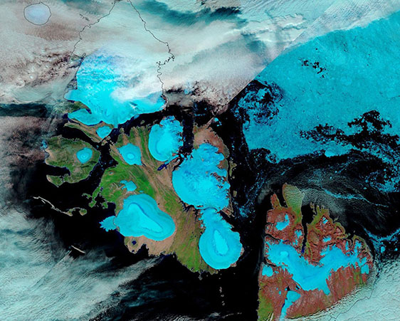
The Severnaya Zemlya archipelago in Russia’s far north is hidden under ice and snow for about ten months each year. It’s so well hidden that this Indiana-sized group of islands wasn’t discovered until 1913, when it was noted by a Russian surveying party. The next year, it was given the name “Emperor Nicholas II Land”. In 1926, however, the name was changed to Severnaya Zemlya, which is said to—quite appropriately— translate to “Northern Land”.
Severnaya Zemlya is made up of four major islands and about 70 smaller ones in the Arctic Ocean just north of the Siberian mainland of Krasnoyarsk Krai. Altogether they cover about 14,300 square miles (37,000 square kilometers) and help form the boundary line between the Kara Sea and the Laptev Sea. The major islands have the evocative names of October Revolution, Bolshevik, Komsomolets, and Pioneer.
The Moderate Resolution Imaging Spectroradiometer (MODIS) on NASA’s Terra satellite acquired a false-color image of Severnaya Zemlya on August 20, 2024. In this type of image, brilliant blue represents ice or snow, clouds look white (although high, cold clouds containing ice crystals may be tinted blue), vegetation appears electric green, deep water is deep blue or black, and open land typically appears tan although, in this image, some land looks rusty tan.
August is typically one of the two months when snow and ice retreats on Severnaya Zemlya, exposing the numerous glaciers that cap each of the major islands. Bolshevik island is the most southerly, with stunning rusty-toned soils contrasting sharply with the blue-ringed glaciers. The three major glaciers on Bolshevik are the Leningrad, Semyonov-Tyan-Shansky, and Kropotkin glaciers.
In the center of the image, the large October Revolution Island is topped with five ice caps: the University in the south, Karpinsky along the eastern coast, Rusanov and Albanov in the north, and Valvilov in the west. Pioneer Island has one relatively small glacier, the Pioneer Glacier. In the north, Komsomolets Island sports a massive ice cap called the Academy of Sciences Ice Cap.
Image Facts
Satellite:
Terra
Date Acquired: 8/20/2024
Resolutions:
1km (82.8 KB), 500m (208.3 KB), 250m (452.9 KB)
Bands Used: 1,4,3
Image Credit:
MODIS Land Rapid Response Team, NASA GSFC
