
Images


October 26, 2024 - Tropical Storm Trami
 Tweet
Tweet
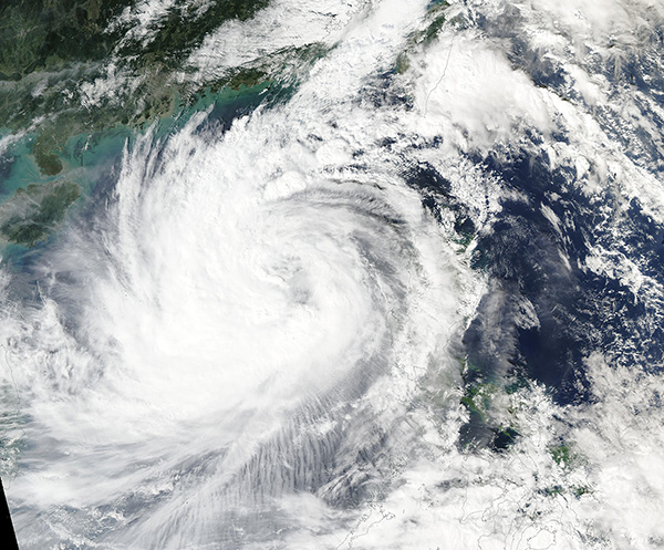
Tropical Storm Trami formed over the western Philippine Sea on October 20, 2024, and began to travel westward towards the Philippines. It made landfall over Isabela Province, in northern Luzon Island on October 24 at tropical storm strength, with maximum sustained winds estimated at 50 miles per hour (80.5 km/h) with higher gusts. Trami (also called Kristine) plowed across Luzon to reach the South China Sea late on that same day. By the morning of October 25, the cloud-filled center of the storm was located about 950 km east of Hainan Island, China, with maximum sustained winds of 58 miles per hour (93 km/h).
Although the storm was not particularly strong, in terms of wind speed, it has proven deadly. On October 25, the National Disaster Risk Reduction and Management Council confirmed at least 13 people died due to the storm with additional people missing. Later that same day, several media outlets updated that number to 82 fatalities, with up to 3 million people impacted by the severe flooding and landslides caused by Tropical Storm Trami.
The Moderate Resolution Imaging Spectroradiometer (MODIS) on NASA’s Aqua satellite acquired a true-color image of Tropical Storm Trami spinning in the South China Sea on October 25. The coast of China and the island of Hainan can be seen to the north and northwest of the storm, while the Philippines remain hidden under cloud in the southeast.
Trami is expected to cross the South China Sea and approach Vietnam over the next several days. It is expected to weaken as it faces increasingly unfavorable conditions on October 26, then it is forecast to make a sharp turn away from the Vietnam coastline without making landfall. After the storm turns away from the coast on October 27, it is expected to travel generally eastward or southeastward until it dissipates on October 29.
Landfall is defined by the center of a storm crossing over land. However, strong winds usually extend far out from the center of the storm, bringing destructive wind, rain, storm surge, and flooding despite a lack of “landfall”.
Image Facts
Satellite:
Aqua
Date Acquired: 10/25/2024
Resolutions:
1km (1.2 MB), 500m (1.8 MB), 250m ( B)
Bands Used: 1,4,3
Image Credit:
MODIS Land Rapid Response Team, NASA GSFC
