Images
October 31, 2024 - Super Typhoon Kong-rey
Tweet
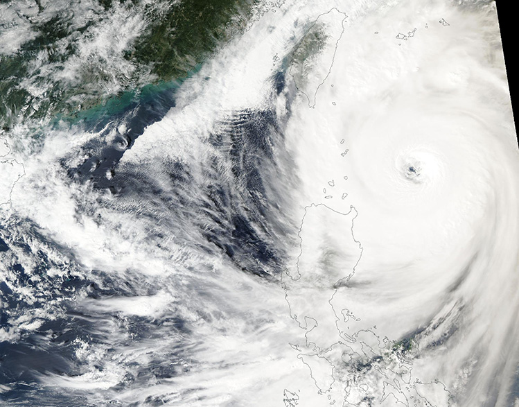
Super Typhoon Kong-Rey was near its peak strength as it headed towards Taiwan on October 30, 2024, when the Moderate Resolution Imaging Spectroradiometer (MODIS) on NASA’s Aqua satellite acquired this true-color image. Maximum sustained winds were estimated at 145 miles per hour (233.4 km/h) near the time the image was acquired. That’s the equivalent of a Category 4 hurricane on the Saffir-Simpson Hurricane Wind Scale.
Kong-Rey (also known as Leon in the Philippines) formed from a depression over the northern Philippine Sea on October 25. It remained at tropical storm strength and gradually strengthening as it moved westward towards the Luzon Strait, north of the Philippines. On October 28, Kong-Rey rapidly intensified and reached its peak strength of 150 mph (241 km/h) on the afternoon of October 29. It then began to very slowly weaken as it tracks towards a landfall near Taitung City, Taiwan, which is expected to be early in the morning of October 31. The Joint Typhoon Warning Center (JTWC) estimates maximum wind speed at landfall will be between 85-95 knots (98-109 mph/157.4-176 km/h).
After landfall, Kong-Rey will continue to weaken as it passes over Taiwan. Once it enters the Taiwan Strait, current models have the storm skirting the shoreline of eastern China as it turns northeast towards Japan. Kong-Rey is forecast to make a second landfall on Kyushu Island, Japan as an extratropical storm on November 1.
Image Facts
Satellite:
Aqua
Date Acquired: 10/30/2024
Resolutions:
1km (467.6 KB), 500m (1.5 MB), 250m (4.5 MB)
Bands Used: 1,4,3
Image Credit:
MODIS Land Rapid Response Team, NASA GSFC


