Images
November 3, 2024 - The Mojave and Colorado Deserts
Tweet
The southeastern portion of California is sometimes called the “California Desert Province” and is divided into the Mojave and the Colorado Deserts. Taken together, these deserts stretch roughly over 25 million acres beginning at Death Valley, in the northern Mojave, to the U.S. border with Mexico in the southern Colorado Desert. According to the National Park Service, the Mojave and Colorado Deserts Biosphere Region (MCDBR) contains North America’s hottest, driest, and lowest places as well as thousands of desert-adapted species and generations of human history.
The two deserts are separated based on their differing climates, elevations, and latitude. The Mojave is the driest of the two and is also sees the most frigid winter temperatures, with longer days of freezing. The Colorado Desert is the western extent of the Sonoran Desert and is more southerly than the Mojave. It has lower elevation, and it often receives rain in the summer.
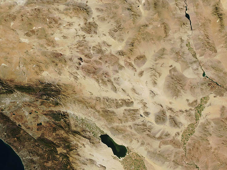
On October 31, 2024, the Moderate Resolution Imaging Spectroradiometer (MODIS) on NASA’s Aqua satellite acquired this true-color image of the deserts of Southeastern California.
A few water features outline the rugged, arid, tan-toned topography of the Mojave Desert and Colorado Deserts seen in this image. In the east, the Colorado River runs along the border of California (west) and Arizona (right). The lake in the southwest is the Salton Sea, a low-lying saline lake. Patches of green mark rich agricultural regions where irrigation helps crops grow despite low annual rainfall. These areas are especially notable near the Salton Sea and along the Colorado River.
Image Facts
Satellite:
Aqua
Date Acquired: 10/31/2024
Resolutions:
1km (57.7 KB), 500m (139.4 KB), 250m (302.5 KB)
Bands Used: 1,4,3
Image Credit:
MODIS Land Rapid Response Team, NASA GSFC


