Images
November 6, 2024 - Snow in Arizona
Tweet
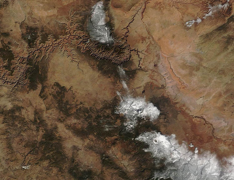
A fast-moving storm system swept across Arizona on November 3, 2024, bringing chilly temperatures and rain across much of the state, with snow accumulating in the higher elevations. According to the National Weather Service, the Snowbowl, located in the San Francisco Peaks, received 4.5 inches (11.4 cm) at 8,379 feet elevation. Flagstaff, located about 15 miles south and roughly 1,000 feet lower, recorded 1.5 inches (3.8 cm) of snowfall. A trace of snow was reported as far south as Tucson, according to data from NOAA’s National Centers for Environmental Information.
The Moderate Resolution Imaging Spectroradiometer (MODIS) on NASA’s Terra satellite acquired a true-color image of freshly fallen snow atop high elevations in Arizona on November 4. The northernmost patch of snow covers the Kaibab Plateau and the North Rim of the Grand Canyon. The San Francisco Peaks and Flagstaff are located in the second patch of snow. Tucson is far south of the lower edge of the image.
Image Facts
Satellite:
Terra
Date Acquired: 11/4/2024
Resolutions:
1km (48.7 KB), 500m (111.6 KB), 250m (219.3 KB)
Bands Used: 1,4,3
Image Credit:
MODIS Land Rapid Response Team, NASA GSFC


