Images
November 10, 2024 - Typhoon Yinxing
Tweet
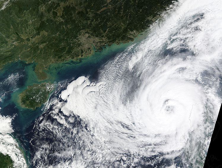
On November 8, 2024, the Moderate Resolution Imaging Spectroradiometer (MODIS) on NASA’s Terra satellite acquired this true-color image of Typhoon Yinxing spinning over the South China Sea. At that time, the powerful typhoon sported a large, partially cloud-filled eye with convective clouds wrapping into the center. Near the time the image was captured, maximum sustained winds were 105 miles per hour (169 km/h), making it the equivalent to a Category 2 hurricane on the Saffir-Simpson Hurricane Wind Scale.
On November 7, Typhoon Yinxing was a super typhoon with maximum sustained winds near 150 mph (241.4 km/h)—the equivalent to a Category 4 hurricane—just before it made landfall on the tip of Luzon Island, Philippines, according to Zoom Earth. As Yinxing crossed the island, windspeeds dropped as the storm unleashed extreme rainfall and heavy storm surges. ReliefWeb reported that Yinxing affected more than 20,650 people across northern Luzon, driving more than 11,000 people to take shelter in evacuation centers. Yinxing, also known as Marce, was the thirteenth typhoon to strike the Philippines this year.
Over the next few days, Typhoon Yinxing is expected to turn southeastward over the South China Sea as it weakens. While the center of the storm should stay well off the coast of Taiwan, that island is expected to receive heavy rain and wind gusts. The forecast from the Joint Typhoon Warning Center (JTWC) shows Yinxing making landfall in Vietnam on November 11 as a remnant low with maximum sustained winds of about 35 miles per hour (56 km/h).
Image Facts
Satellite:
Terra
Date Acquired: 11/8/2024
Resolutions:
1km (605.7 KB), 500m (1.9 MB), 250m (4.5 MB)
Bands Used: 1,4,3
Image Credit:
MODIS Land Rapid Response Team, NASA GSFC


