Images
November 11, 2024 - Hurricane Rafael
Tweet
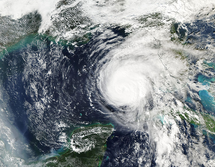
Hurricane Rafael continued to churn in the Gulf of Mexico on November 7, 2024. It was fighting wind shear but still trying to strengthen. When the Moderate Resolution Imaging Spectroradiometer (MODIS) on NASA’s Aqua satellite acquired this true-color image of Rafael on November 7, the storm was a Category 2 hurricane with maximum sustained winds of about 105 miles per hour (169 km/h).
On November 8, winds picked up to 120 miles per hour (193 km/h)—Category 3—before Rafael began to lose the battle against increasingly unfavorable conditions. By the morning of November 11, Rafael’s maximum sustained winds had dropped to 40 miles per hour (65 km/h), which is a weak tropical storm. It was located about 600 kilometers (373 miles) north-northwest of Progreso, Mexico, according to the National Hurricane Center (NHC).
The NHC forecast that Tropical Storm Rafael would meander over the central Gulf of Mexico through November 11, then make a turn to travel south-southwest. Wind speeds will continue to drop as the storm degenerates into a post-tropical remnant by November 12. The storm will continue to push swells that may cause life-threatening rip currents along portions of the northern and western Gulf Coast through November 11.
Image Facts
Satellite:
Aqua
Date Acquired: 11/7/2024
Resolutions:
1km (1.1 MB), 500m (2.8 MB), 250m ( B)
Bands Used: 1,4,3
Image Credit:
MODIS Land Rapid Response Team, NASA GSFC


