Images
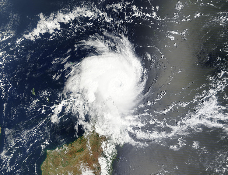
December 14, 2024 - Tropical Cyclone Chido off of Madagascar
Tweet
Tropical Cyclone Chido formed over the southeastern Indian Ocean on December 10, 2024. Taking a westward track, Chido strengthened rapidly as it approached Madagascar and Mozambique. By December 12, maximum sustained winds had reached 155 miles per hour (250 km/h) the equivalent of a strong Category 4 hurricane on the Saffir-Simpson Hurricane Wind Scale (Category 5 begins at 157 mph/252 km/h). According to news reports, Chido made landfall over Agaléga North Island, Mauritius, while still at Category 4 strength on December 12.
By December 13, when the Moderate Resolution Imaging Spectroradiometer (MODIS) on NASA’s Terra satellite acquired this true-color image of the storm, maximum sustained winds had dropped to about 120 miles per hour (193 km/h), equivalent to a Category 3 hurricane.
Tropical Cyclone Chido is forecast to continue to travel west-southwest over the next two days, at first weakening but then strengthening is expected to resume, according to the Joint Typhoon Warning Center (JTWC). The storm will pass close to the Glorioso Islands, Mayotte, and the Comoros archipelago on December 14 before making landfall in Northern Mozambique on December 15. Maximum sustained winds at landfall are expected to be at or near 130 mph (209 km/h) at landfall.
According to ReliefWeb, about 2.7 million people in six countries in southern Africa including the Comoros (368,508), Madagascar (135,838), Malawi (440,479), Mauritius (225), Mozambique (1,753,234) and Seychelles (16) are projected to be affected by the passage of the intense tropical cyclone Chido.
Image Facts
Satellite:
Terra
Date Acquired: 12/13/2024
Resolutions:
1km (1.3 MB), 500m (3.6 MB), 250m (5.2 MB)
Bands Used: 1,4,3
Image Credit:
MODIS Land Rapid Response Team, NASA GSFC


