
Images


March 16, 2025 - Ice Retreats on Lake Erie


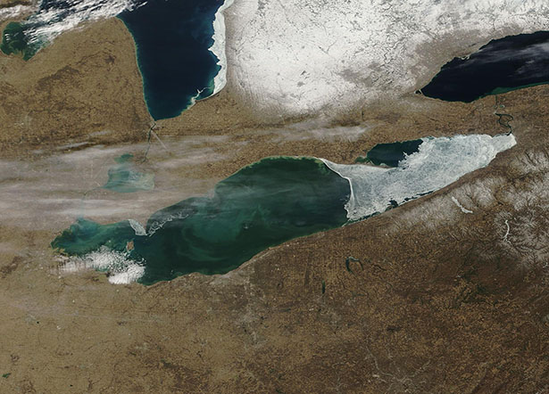
March 11, 2025 February 22, 2025
Warming air temperatures and lengthening daylight hours spurred rapid melting of Lake Erie’s ice cover in early March 2025. According to NOAA’s Great Lakes Environmental Research Laboratory (GLERL), ice covered about 28 percent of the surface of Lake Erie on March 11. That’s substantially down from peak coverage, which was 95.78 percent coverage on February 20.
The Moderate Resolution Imaging Spectroradiometer (MODIS) on NASA’s Terra satellite acquired this true-color image of Lake Erie’s fading ice cover on March 11. A second Terra MODIS image of the same area was acquired on February 22, when ice cover was just below peak, at 94.56 percent. The two images can be compared by clicking on the date.
On March 11, lake ice, which appears bright white, covers most of the eastern section of the lake. In contrast, the western part of the lake is ice-free, allowing the blue water to show through. Swirls of tan and green visible within the open water mark a bloom of phytoplankton (microscopic plant-like organisms) and sediment. Thin lines of pale white clouds stretch over Lake Erie while lake-effect snow covers parts of New York and Pennsylvania that sit to the southeast of Lake Erie. In the north, white snow lies on the ground in Ontario, Canada, and a thin strip of ice clings to the southeastern shoreline of Lake Huron.
On February 22, the entire area is clearly in the grip of winter. Snow covers almost all the area and Lake Erie, except for a small section on the west end and along a small stretch along the northern shoreline is completely covered in white ice. Lake Huron also has more ice, although some water still remains ice-free.
Image Facts
Satellite:
Terra
Date Acquired: 3/11/2025
Resolutions:
1km (102.8 KB), 500m (306.9 KB), 250m (572.9 KB)
Bands Used: 1,4,3
Image Credit:
MODIS Land Rapid Response3/5/2025 Team, NASA GSFC
