
Images


March 28, 2025 - Carolinas Burning
 Tweet
Tweet
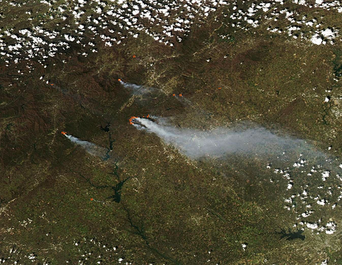
Fierce wildfires burned across the forests of the Blue Ridge Mountains of western North Carolina and northwestern South Carolina in late March 2025. The Moderate Resolution Imaging Spectroradiometer (MODIS) on NASA’s Aqua satellite acquired this true-color image of more than a half-dozen blazes in the two states on March 26.
Each red “hot spot” marks an area where the thermal bands on the MODIS instrument detected high temperatures. When combined with typical smoke, as in this image, such hot spots are diagnostic for actively burning fire.
The largest fires visible are in South Carolina, and include the Table Rock Fire, in Pickens County and the adjacent Table Rock Complex Fire, in Greenville County. The Table Rock Fire was first sighted on March 22 and has burnt 8,679 acres as of March 27, according to the Hazard Mapping System published by the Greenville Times. The Table Rock Complex Fire began on March 24 and consumed 10,671 acres by March 27. Both of these fires are very near the border with North Carolina. A large plume of gray smoke blows southeast from the fires and crosses the city of Greenville, South Carolina, which appears as a group of gray-toned pixels. Greenville is nearly obscured from view
by the thick smoke.
While the exact cause of ignition remains undetermined for most of the Carolinas wildfires, extremely low relative humidity, strong gusting wind, abundant fuel, and lack of rain created conditions perfect for rapid fire ignition from the least spark. Many of the fires burn in rugged mountain terrain, some of which no longer have adequate road access after landslides and wind damage of Hurricane Helene, which left widespread and historic devastation in this area only six months ago.
Hurricane Helene made landfall in Florida on September 27, 2024, as a Category 4 storm, and left a 50-mile wide swath of damage from Florida to Ashville, North Carolina, according to The Weather Channel. More than 30 inches (76 cm) of rain fell in western North Carolina, landing on ground that had already been saturated by earlier storms. This triggered 78 landslides, wiped out roads, and downed thousands of acres of trees in North Carolina alone. Heavy damage to homes and trees also occurred in parts of South Carolina, Tennessee, and Georgia. While clean-up efforts have been steadily ongoing, most of the timber, especially in wildland and difficult terrain, has been left in place and now has become extremely dry and flammable fuel.
Red-flag warnings for extreme fire risk remain in place as of May 27, but system that is anticipated to carry soaking spring rain is in the forecast within the next few days. This will be welcome assistance to firefighting efforts and to residents coping not just with the fire risks, but also with the smoke that tends to collect especially heavily in the mountain valleys.
Image Facts
Satellite:
Aqua
Date Acquired: 3/26/2025
Resolutions:
1km (62.2 KB), 500m (157.6 KB), 250m (320.9 KB)
Bands Used: 1,4,3
Image Credit:
MODIS Land Rapid Response Team, NASA GSFC
Fierce wildfires burned across the forests of the Blue Ridge Mountains of western North Carolina and northwestern South Carolina in late March 2025. The Moderate Resolution Imaging Spectroradiometer (MODIS) on NASA’s Aqua satellite acquired this true-color image of more than a half-dozen blazes in the two states on March 26.
Each red “hot spot” marks an area where the thermal bands on the MODIS instrument detected high temperatures. When combined with typical smoke, as in this image, such hot spots are diagnostic for actively burning fire.
The largest fires visible are in South Carolina, and include the Table Rock Fire, in Pickens County and the adjacent Table Rock Complex Fire, in Greenville County. The Table Rock Fire was first sighted on March 22 and has burnt 8,679 acres as of March 27, according to the Hazard Mapping System published by the Greenville Times. The Table Rock Complex Fire began on March 24 and consumed 10,671 acres by March 27. Both of these fires are very near the border with North Carolina. A large plume of gray smoke blows southeast from the fires and crosses the city of Greenville, South Carolina, which appears as a group of gray-toned pixels. Greenville is nearly obscured from view by the thick smoke.
While the exact cause of ignition remains undetermined for most of the Carolinas wildfires, extremely low relative humidity, strong gusting wind, abundant fuel, and lack of rain created conditions perfect for rapid fire ignition from the least spark. Many of the fires burn in rugged mountain terrain, some of which no longer have adequate road access after landslides and wind damage of Hurricane Helene, which left widespread and historic devastation in this area only six months ago.
Hurricane Helene made landfall in Florida on September 27, 2024, as a Category 4 storm, and left a 50-mile wide swath of damage from Florida to Ashville, North Carolina, according to The Weather Channel. More than 30 inches (76 cm) of rain fell in western North Carolina, landing on ground that had already been saturated by earlier storms. This triggered 78 landslides, wiped out roads, and downed thousands of acres of trees in North Carolina alone. Heavy damage to homes and trees also occurred in parts of South Carolina, Tennessee, and Georgia. While clean-up efforts have been steadily ongoing, most of the timber, especially in wildland and difficult terrain, has been left in place and now has become extremely dry and flammable fuel.
Red-flag warnings for extreme fire risk remain in place as of May 27, but system that is anticipated to carry soaking spring rain is in the forecast within the next few days. This will be welcome assistance to firefighting efforts and to residents coping not just with the fire risks, but also with the smoke that tends to collect especially heavily in the mountain valleys.
Image Facts
Satellite:
Aqua
Date Acquired: 3/26/2025
Resolutions:
1km (62.2 KB), 500m (157.6 KB), 250m (320.9 KB)
Bands Used: 1,4,3
Image Credit:
MODIS Land Rapid Response Team, NASA GSFC
