
Images


April 25, 2024 - Great Salt Lake
 Tweet
Tweet
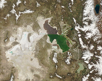
After reaching an all-time low water level and teetering on the edge of ecological collapse in late 2022, rising water levels in the Great Salt Lake have water managers in Utah optimistic in April 2024.
According to the Utah Water Conditions Update, published by Utah Division of Water Resources on April 18, 2024, the water level has risen about 2.5 feet in the since October 2023. In addition, on April 24, local news media reported that Great Salt Lake Commissioner Brian Steed said that the south arm has risen to 4,194.6 feet, which is up nearly six feet from late 2022. The north and south arm are separated by a railroad causeway, which keeps limits mixing.
This impressive rebound can be attributed primarily to heavy snowpack accumulated this winter as well as precipitation-filled March. The Natural Resources Conservation Service’s April Water Supply Report notes that Utah received 150 percent of its typical snow water equivalent for March. The state also received 156 percent of normal precipitation during March, bringing the water-year-to-date value to 117 percent of normal, up 6 percent from the end of February.
Water levels in the Great Salt Lake naturally fluctuate throughout the year, with the highest levels most often reached in May, when runoff from winter’s snowpack is nearly complete and local air temperatures remain relatively mild. In summer, high temperatures can reach brutal levels, runoff ceases to flow, and rainfall becomes rare. Under these conditions, evaporation reduces water levels, sometimes dramatically. It is certain levels in the Great Salt Lake will have decreased by the end of summer. The question remains as to how much.
On April 18, 2024, the Moderate Resolution Imaging Spectroradiometer (MODIS) on NASA’s Terra satellite acquired a true-color image of Utah’s iconic Great Salt Lake. Not only does the lake appear larger than usual, green-tinted water is visible both northeast and east of the lake. A patch of water also is evident on the salt pan west of the Great Salt Lake. The Wasatch Mountains, east of the lake, remain covered with bright white snow.
The sharp difference in colors is caused by the restriction in water flow from the railroad causeway. The eye-catching tint of the north arm comes from the fact that the Great Salt Lake is hypersaline, typically 3-5 times saltier than the ocean, and the high salinities support sets of plants and animals that affect the light-absorbing qualities of the water. North of the causeway salinities are higher, and the water turns red from the pigments of halophilic (salt-loving) bacteria.
Image Facts
Satellite:
Terra
Date Acquired: 4/18/2024
Resolutions:
1km (144.2 KB), 500m (380.9 KB), 250m (846.7 KB)
Bands Used: 1,4,3
Image Credit:
MODIS Land Rapid Response Team, NASA GSFC
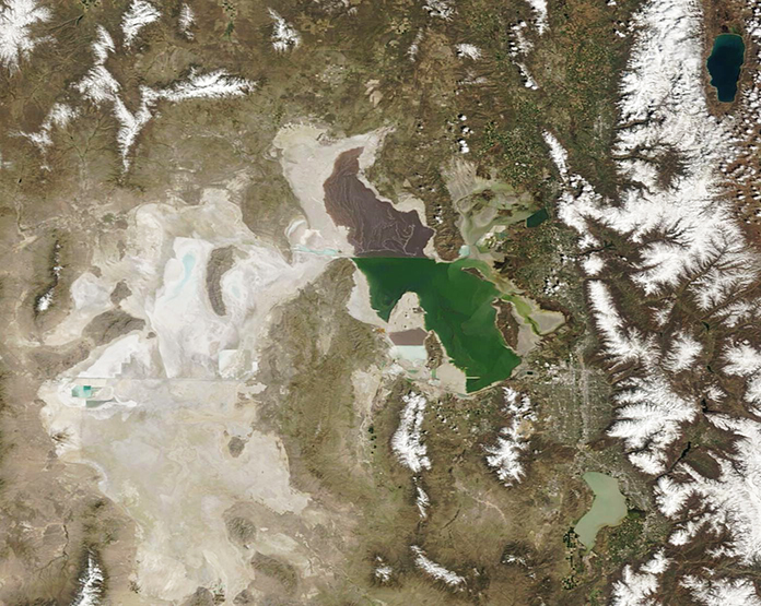
