
Images


July 2, 2024 - Hurricane Beryl Savages the Grenadines
 Tweet
Tweet
The first Atlantic hurricane of 2024 produced dangerous winds and life-threatening storm surge as it barreled into the Caribbean’s Grenadine Islands. On the morning of July 1, Hurricane Beryl made landfall on Carriacou Island as a Category 4 storm with maximum sustained winds of 150 miles (240 kilometers) per hour. It is the strongest hurricane on record to pass through the Grenadines, based on NOAA data that began in 1851.
Shortly after landfall, Prime Minister Dickon Mitchell stated that damage in Carriacou and Petit Martinique was expected to be extreme. “In a half an hour, Carriacou was flatted,” he said. Power was down across the Grenadines, making early assessment of the situation difficult but at least one person has been reported to have died from the storm. Early assessments of Union Island, north of Grenada, suggests that about 90 percent of building have been severely damaged.
Hurricane Beryl continued to intensify as it crossed the Grenadines. At 8:00 p.m. EDT on July 1 (0000 UTC on July 2), the National Hurricane Center (NHC) advised that the storm was carrying maximum sustained winds of 155 miles per hour (250 km/h)—just 2 miles per hour shy of a Category 5 hurricane. At that time, it was located about 575 miles (925 km) east-southeast of Isla Beata, Dominican Republic and was moving west-northwest.
The NHC forecasts that the center of Beryl will move quickly away from the southern Windward Islands and continue to track west-northwestward during the next few days. The center of Hurricane Beryl is expected to pass near Jamaica on July 3. Hurricane warnings are already in place in Jamaica as the island prepares for the approaching storm.
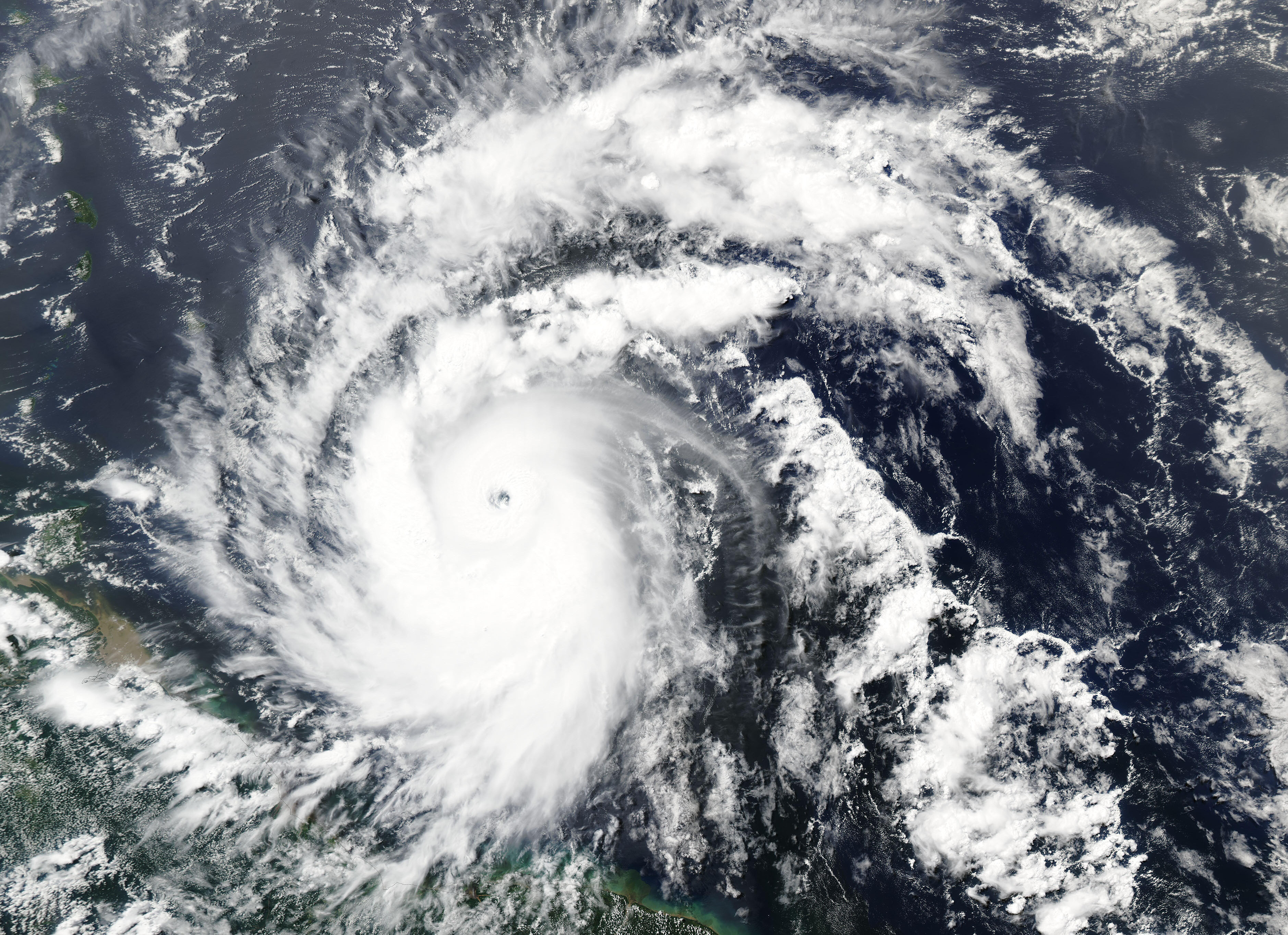
The Moderate Resolution Imaging Spectroradiometer (MODIS) on NASA’s Aqua satellite acquired this true-color image of Hurricane Beryl on June 30. It was approaching the Grenadines at the time and was a large storm tightly wrapping around a distinct, open eye.
Beryl formed as a tropical depression in the central tropical Atlantic on June 28 and then became a tropical storm on June 29. The storm rapidly intensified from a tropical storm to a powerful Category 4 in less than 24 hours. “Rapid intensification” occurs when wind speeds increase by at least 35 miles (56 kilometers) per hour, over 24 hours.
The National Hurricane Center noted that atmospheric conditions in late June are typically unfavorable for storm intensification in this part of the Atlantic. They also pointed out that very few storms have formed this far east so early in the season.
Image Facts
Satellite:
Aqua
Date Acquired: 6/30/2024
Resolutions:
1km (701.4 KB), 500m (2 MB), 250m (4.3 MB)
Bands Used: 1,4,3
Image Credit:
MODIS Land Rapid Response Team, NASA GSFC
The first Atlantic hurricane of 2024 produced dangerous winds and life-threatening storm surge as it barreled into the Caribbean’s Grenadine Islands. On the morning of July 1, Hurricane Beryl made landfall on Carriacou Island as a Category 4 storm with maximum sustained winds of 150 miles (240 kilometers) per hour. It is the strongest hurricane on record to pass through the Grenadines, based on NOAA data that began in 1851.
Shortly after landfall, Prime Minister Dickon Mitchell stated that damage in Carriacou and Petit Martinique was expected to be extreme. “In a half an hour, Carriacou was flatted,” he said. Power was down across the Grenadines, making early assessment of the situation difficult but at least one person has been reported to have died from the storm. Early assessments of Union Island, north of Grenada, suggests that about 90 percent of building have been severely damaged.
Hurricane Beryl continued to intensify as it crossed the Grenadines. At 8:00 p.m. EDT on July 1 (0000 UTC on July 2), the National Hurricane Center (NHC) advised that the storm was carrying maximum sustained winds of 155 miles per hour (250 km/h)—just 2 miles per hour shy of a Category 5 hurricane. At that time, it was located about 575 miles (925 km) east-southeast of Isla Beata, Dominican Republic and was moving west-northwest.
The NHC forecasts that the center of Beryl will move quickly away from the southern Windward Islands and continue to track west-northwestward during the next few days. The center of Hurricane Beryl is expected to pass near Jamaica on July 3. Hurricane warnings are already in place in Jamaica as the island prepares for the approaching storm.
The Moderate Resolution Imaging Spectroradiometer (MODIS) on NASA’s Aqua satellite acquired this true-color image of Hurricane Beryl on June 30. It was approaching the Grenadines at the time and was a large storm tightly wrapping around a distinct, open eye.
Beryl formed as a tropical depression in the central tropical Atlantic on June 28 and then became a tropical storm on June 29. The storm rapidly intensified from a tropical storm to a powerful Category 4 in less than 24 hours. “Rapid intensification” occurs when wind speeds increase by at least 35 miles (56 kilometers) per hour, over 24 hours.
The National Hurricane Center noted that atmospheric conditions in late June are typically unfavorable for storm intensification in this part of the Atlantic. They also pointed out that very few storms have formed this far east so early in the season.
Image Facts
Satellite:
Aqua
Date Acquired: 6/30/2024
Resolutions:
1km (701.4 KB), 500m (2 MB), 250m (4.3 MB)
Bands Used: 1,4,3
Image Credit:
MODIS Land Rapid Response Team, NASA GSFC
