
Images


September 16, 2025 - Severe Flooding in South Sudan


September 14, 2025
March 17, 2025
Tweet
Spanning an area of 644,329 square kilometers (248,777 square miles), South Sudan is slightly smaller than the U.S. state of Texas. Sitting in northeast Africa, the land-locked country is surrounded by the Central Africa Republic, Democratic Republic of the Congo, Ethiopia, Kenya, Sudan, and Uganda. The White Nile flows through the country and feeds the Sudd (Al-Sudd), a wetlands area that spans more than 100,000 square kilometers (38,610 square miles) in the center of the country.
South Sudan has a tropical climate with distinct wet and dry seasons. The wet season often starts as early as April and sometimes continues into December. By August or September, local precipitation as well as runoff from monsoonal rains in the Ethiopian Highlands typically cause flooding in Al-Sudd and, sometimes, across South Sudan. At times, flooding can be mild but, in some years, it can be catastrophic. 2025 is well on its way to catastrophe.
On September 15, 2025, when UNHCR, the UN Refugee Agency, published Briefing Notes regarding South Sudan. The report states that, in recent weeks, rising waters have submerged vast areas in Jonglei, Upper Nile, and Unity states, displacing 100,000 people. Many of these were internally displaced persons, who already had been forced to flee their homes due to renewed conflict since February 2025. The hardest-hit areas are already experiencing critical levels of food insecurity and still suffering the consequences of devastating flooding in 2022.
According to UNHCR, “If the flooding continues, up to 400,000 people are likely to be displaced by the end of the year, exceeding flood displacement levels seen in 2024. Peak impacts are expected between September and October, threatening to cut off entire communities, exacerbate hunger and heighten protection risks, particularly for women and girls.” Not only have homes, schools, and medical facilities been damaged, farmlands and pasture have been destroyed, along with livestock. Lack of safe drinking water along with poor sanitation has increased risk of contracting disease, including cholera, which had infected over 15,000 people as of the end of August.
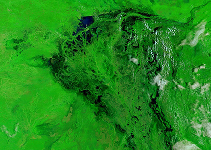
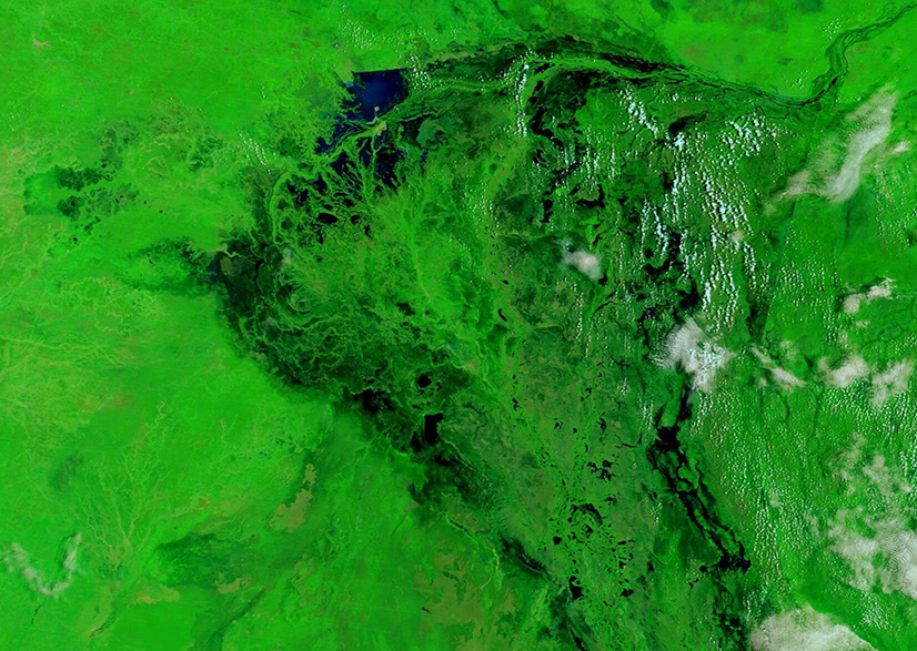
The Moderate Resolution Imaging Spectroradiometer (MODIS) on NASA’s Aqua satellite acquired a pair of false-color images that can be compared to help visualize the severe flooding in 2025. The first (top image) was acquired on September 14, 2025, and the second was acquired on March 17, 2025, near the end of the dry season. Both images show the exact same area and are centered on The Sudd. In this type of false-color image, water is dark blue, vegetation appears green, cloud looks white, and dry land shows as tan tones.
The September 14 image clearly shows the area was heavily inundated by water on that date. All river channels appeared full to overflowing and nearly surrounded the central Sudd wetlands. In addition, all the land viewable in the image was covered with green, indicating that moisture had been present long enough to spur heavy vegetative growth over a wide area. Clicking on the March 14 image shows a dramatically different scene. Here, only The Sudd itself remains green, with a lake visible in the northwest. However, rivers are either not visible or carry sparse pale sediment, suggesting very low water levels. In addition, The Sudd was surrounded by tan land, indicating little or no vegetation and very dry conditions.
Image Facts
Satellite:
Aqua
Date Acquired: 9/14/2025
Resolutions:
1km (195.5 KB), 500m (488.7 KB), 250m (319.3 KB)
Bands Used: 7,2,1
Image Credit:
MODIS Land Rapid Response Team, NASA GSFC
September 14, 2025 March 17, 2025
Spanning an area of 644,329 square kilometers (248,777 square miles), South Sudan is slightly smaller than the U.S. state of Texas. Sitting in northeast Africa, the land-locked country is surrounded by the Central Africa Republic, Democratic Republic of the Congo, Ethiopia, Kenya, Sudan, and Uganda. The White Nile flows through the country and feeds the Sudd (Al-Sudd), a wetlands area that spans more than 100,000 square kilometers (38,610 square miles) in the center of the country.
South Sudan has a tropical climate with distinct wet and dry seasons. The wet season often starts as early as April and sometimes continues into December. By August or September, local precipitation as well as runoff from monsoonal rains in the Ethiopian Highlands typically cause flooding in Al-Sudd and, sometimes, across South Sudan. At times, flooding can be mild but, in some years, it can be catastrophic. 2025 is well on its way to catastrophe.
On September 15, 2025, when UNHCR, the UN Refugee Agency, published Briefing Notes regarding South Sudan. The report states that, in recent weeks, rising waters have submerged vast areas in Jonglei, Upper Nile, and Unity states, displacing 100,000 people. Many of these were internally displaced persons, who already had been forced to flee their homes due to renewed conflict since February 2025. The hardest-hit areas are already experiencing critical levels of food insecurity and still suffering the consequences of devastating flooding in 2022.
According to UNHCR, “If the flooding continues, up to 400,000 people are likely to be displaced by the end of the year, exceeding flood displacement levels seen in 2024. Peak impacts are expected between September and October, threatening to cut off entire communities, exacerbate hunger and heighten protection risks, particularly for women and girls.” Not only have homes, schools, and medical facilities been damaged, farmlands and pasture have been destroyed, along with livestock. Lack of safe drinking water along with poor sanitation has increased risk of contracting disease, including cholera, which had infected over 15,000 people as of the end of August.
The Moderate Resolution Imaging Spectroradiometer (MODIS) on NASA’s Aqua satellite acquired a pair of false-color images that can be compared to help visualize the severe flooding in 2025. The first (top image) was acquired on September 14, 2025, and the second was acquired on March 17, 2025, near the end of the dry season. Both images show the exact same area and are centered on The Sudd. In this type of false-color image, water is dark blue, vegetation appears green, cloud looks white, and dry land shows as tan tones.
The September 14 image clearly shows the area was heavily inundated by water on that date. All river channels appeared full to overflowing and nearly surrounded the central Sudd wetlands. In addition, all the land viewable in the image was covered with green, indicating that moisture had been present long enough to spur heavy vegetative growth over a wide area. Clicking on the March 14 image shows a dramatically different scene. Here, only The Sudd itself remains green, with a lake visible in the northwest. However, rivers are either not visible or carry sparse pale sediment, suggesting very low water levels. In addition, The Sudd was surrounded by tan land, indicating little or no vegetation and very dry conditions.
Image Facts
Satellite:
Aqua
Date Acquired: 9/14/2025
Resolutions:
1km (195.5 KB), 500m (488.7 KB), 250m (319.3 KB)
Bands Used: 7,2,1
Image Credit:
MODIS Land Rapid Response Team, NASA GSFC
