
Images


April 29, 2020 - Greening in the Taklamakan Desert
 Tweet
Tweet
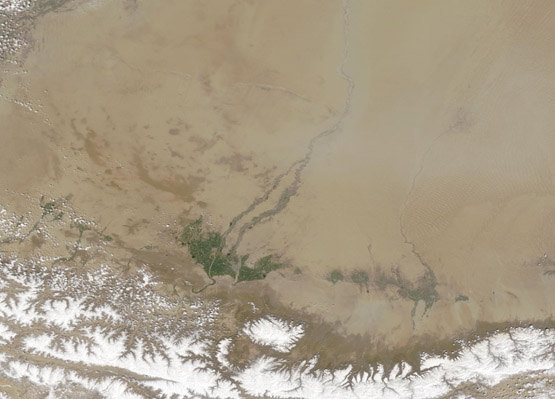
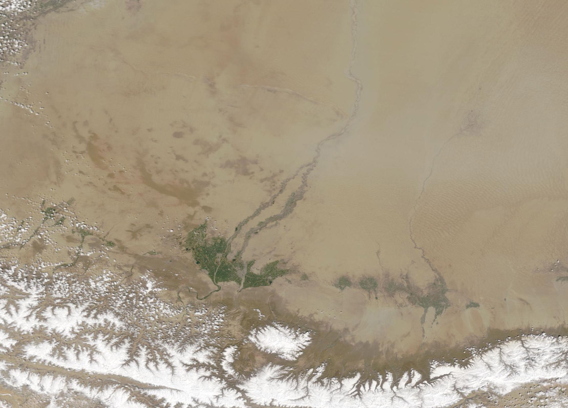
The Taklamakan desert wins the prize as China’s biggest, hottest and driest desert. The vast shifting-sand desert stretches over an area measuring about 130,500 square miles (338,000 square km)—slightly larger than the state of New Mexico—in western China. Sand dunes cover about 85 percent of the Taklamakan, often feeding massive dust storms.
Isolated from the Asian monsoon and from Arctic storms, the central basin receives less than 10 millimeters (0.4 inches) of precipitation per year. In such a parched environment, plants are rare, and yet they exist. When water comes to the parched land, vegetation begins to thrive.
Runoff from the Tien Shan Mountains and the Kunlun Shan Mountains feed rivers, which in turn support vegetation. Two rivers flowing from the Kunlun Mountains, the White Jade and the Karakash, meet in the desert to form the Hotan River. The Hotan then flows 180 miles (290 km) to meet the Tarim River. The Hotan stays dry most of the year, but fills with snow melt and precipitation from the mountains in the spring and summer.
On April 24, 2020, the Moderate Resolution Imaging Spectrometer (MODIS) on board NASA’s Terra satellite acquired a true-color image of spring greening in the Taklamakan Desert. Although partially veiled by a dust storm, the course of the Hotan River is colored in green, leading to a broad green swath near the southwestern edge of the desert.
While a single image can easily show the green flush in the dry desert, a comparison of two MODIS images of the same area can show change over time. Thanks to the NASA Worldview app, a rollover comparison between this image and one acquired by Terra’s MODIS on January 10, 2020 can be seen here.
The NASA Worldview app provides a satellite's perspective of the planet as it looks today and as it has in the past through daily satellite images. Worldview is part of NASA’s Earth Observing System Data and Information System. EOSDIS makes the agency's large repository of data accessible and freely available to the public.
Image Facts
Satellite:
Terra
Date Acquired: 4/24/2020
Resolutions:
1km (65.4 KB), 500m (184.3 KB), 250m (275.7 KB)
Bands Used: 1,4,3
Image Credit:
MODIS Land Rapid Response Team, NASA GSFC
