
Images


September 12, 2024 - Devastating Floods Strike the Sahel


September 8, 2024
September 6, 2023
Tweet
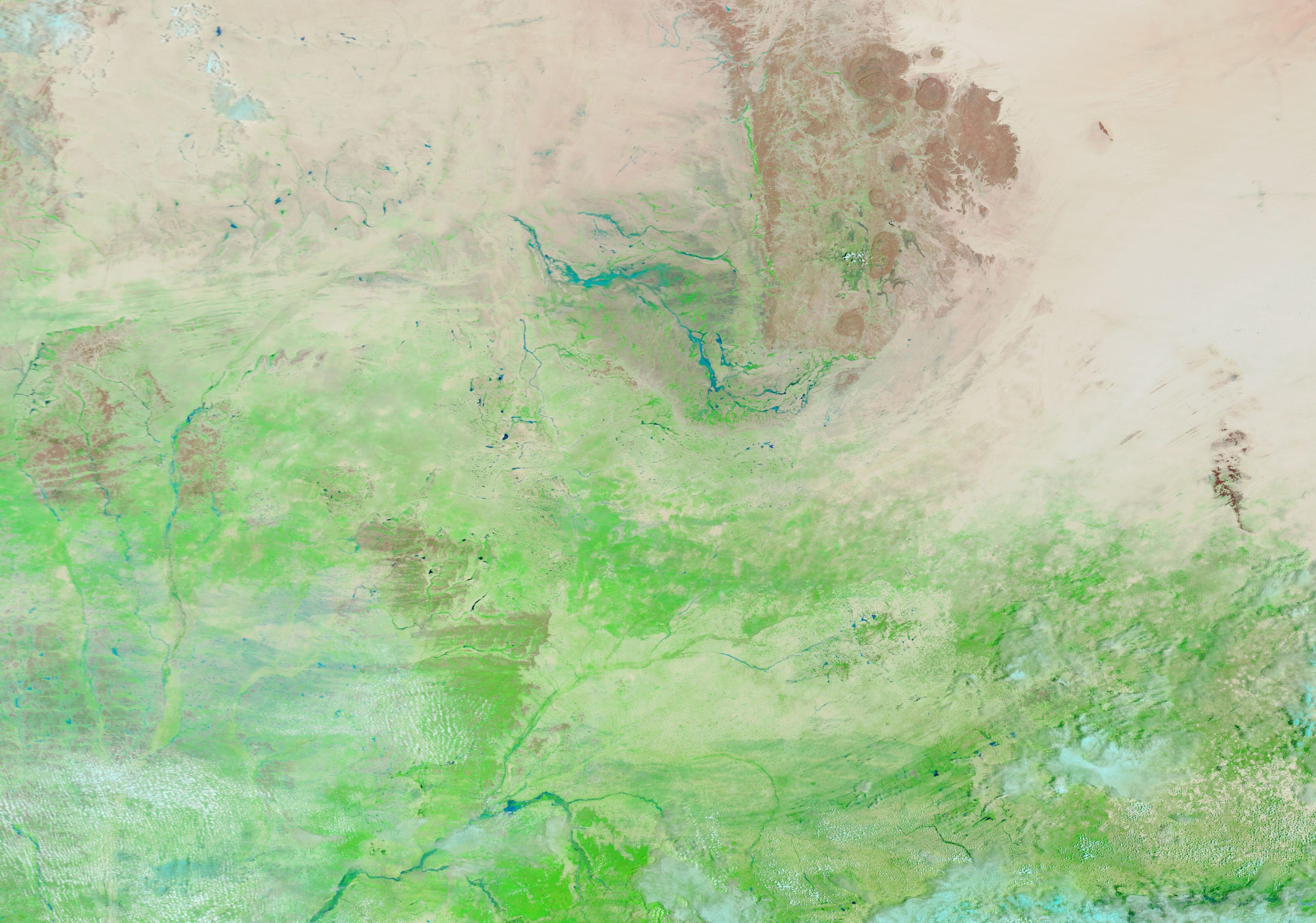
In Africa, a margin of semi-arid grassland known as the Sahel fringes the southern limit of the expansive and arid Sahara Desert. Although it is dry most of the year, rainfall picks up in June and September, and by August the Sahel wears a flush of green from vegetative growth spurred by precipitation. In 2024, however, torrential rains proved devastating, triggering widespread flooding instead of gentle greening.
According to a report published on August 23 by the African Centre for Meteorological Applications for Development (ClimSA), many parts of the Sahel had already been devastated by that date, including the northern regions that usually receive little rainfall. The report states, “many towns and villages are under water, and hundreds of people have lost their lives, either by drowning or as a result of homes collapse…bridges have collapsed, roads are completely flooded and impassable, hundreds of houses have been destroyed, health centers ravaged, fields damaged, hundreds of tons of food washed away by the waters, as well as thousands of herds of cattle carried away by the currents.” The most affected areas include northern and central Chad, northern Niger, Mali, and Burkina Faso.
On September 8, 2024, the Moderate Resolution Imaging Spectroradiometer (MODIS) on NASA’s Terra satellite acquired a false-color image centered on northern Niger. In this type of image open land, sand, and rocky outcroppings range from tan to brown in color. Vegetation is green and water looks blue. Clouds are usually white but may be tinted with a soft electric blue. The top image is paired with a second false-color Terra MODIS image of the exact same area acquired on September 6, 2023, to allow comparison of this year’s flooded scene with a more normal year.
The 2024 image shows widespread greening, even into the far north, and around and on the rugged, rocky terrain of the circular Air Mountains. At the southwest foot of the Air Mountains, the 2023 image shows mostly open land with slight greening, but in 2024 the same area is covered by heavily flooded lines tracking normally dry riverbeds and farmland. A similar change can be seen in the lower left (southwestern) section of the image.
The town of Niamey, the capital of Niger, is located in the flooded area near the Air Mountains. ClimSA reports that the national road RN1 flooded on August 16. The resulting damage isolated the capital from six regions of the country and cut off a vital route for the supply of food and fuel to the city.
According to an article published by ReliefWeb, as of September 4, Niger's Ministry of Humanitarian Action and Disaster Management (MAH/GC) registered a total of 710,767 people impacted by flooding (94,783 households), including 273 deaths. In addition, 73,582 houses had collapsed, and 17,762 livestock had been killed.
On September 12, the Ministry of Health reported a cholera outbreak had sickened at least 172. Cholera is an acute disease caused by a water-borne bacteria which, when ingested, results in diarrhea and severe dehydration. It often follows floods and other natural disasters when sanitation is poor. According to the World Health Organization, cholera can kill within hours if left untreated. Antibiotics, intravenous fluids, and vaccination—all of which are difficult to attain in severe flooding—can save lives.
While Niger has been heavily impacted by this year’s floods, it is not alone. According to an August 15 situation report published by the United Nations Office for the Coordination of Humanitarian Affairs (OCHA), torrential rains and severe flooding had already affected widespread areas in Central African Republic, Chad, Côte d'Ivoire, Democratic Republic of the Congo, Liberia, Mali, Nigeria, Niger, and Togo, with at least 76 deaths to that date. The rains have continued since August, dramatically increasing the impact and the devastation triggered by the intense rains.
On September 5, the NASA’s Earth Observatory Image of the Day described flooding in Sudan, a country at the northeastern tip of the Sahel region. Titled “Floods Swamp Sudan”, the images and story can be found here.
Image Facts
Satellite:
Terra
Date Acquired: 9/8/2024
Resolutions:
1km (261.4 KB), 500m (659.1 KB), 250m (1.8 MB)
Bands Used: 7,2,1
Image Credit:
MODIS Land Rapid Response Team, NASA GSFC
September 8, 2024 September 6, 2023
In Africa, a margin of semi-arid grassland known as the Sahel fringes the southern limit of the expansive and arid Sahara Desert. Although it is dry most of the year, rainfall picks up in June and September, and by August the Sahel wears a flush of green from vegetative growth spurred by precipitation. In 2024, however, torrential rains proved devastating, triggering widespread flooding instead of gentle greening.
According to a report published on August 23 by the African Centre for Meteorological Applications for Development (ClimSA), many parts of the Sahel had already been devastated by that date, including the northern regions that usually receive little rainfall. The report states, “many towns and villages are under water, and hundreds of people have lost their lives, either by drowning or as a result of homes collapse…bridges have collapsed, roads are completely flooded and impassable, hundreds of houses have been destroyed, health centers ravaged, fields damaged, hundreds of tons of food washed away by the waters, as well as thousands of herds of cattle carried away by the currents.” The most affected areas include northern and central Chad, northern Niger, Mali, and Burkina Faso.
On September 8, 2024, the Moderate Resolution Imaging Spectroradiometer (MODIS) on NASA’s Terra satellite acquired a false-color image centered on northern Niger. In this type of image open land, sand, and rocky outcroppings range from tan to brown in color. Vegetation is green and water looks blue. Clouds are usually white but may be tinted with a soft electric blue. The top image is paired with a second false-color Terra MODIS image of the exact same area acquired on September 6, 2023, to allow comparison of this year’s flooded scene with a more normal year.
The 2024 image shows widespread greening, even into the far north, and around and on the rugged, rocky terrain of the circular Air Mountains. At the southwest foot of the Air Mountains, the 2023 image shows mostly open land with slight greening, but in 2024 the same area is covered by heavily flooded lines tracking normally dry riverbeds and farmland. A similar change can be seen in the lower left (southwestern) section of the image.
The town of Niamey, the capital of Niger, is located in the flooded area near the Air Mountains. ClimSA reports that the national road RN1 flooded on August 16. The resulting damage isolated the capital from six regions of the country and cut off a vital route for the supply of food and fuel to the city.
According to an article published by ReliefWeb, as of September 4, Niger's Ministry of Humanitarian Action and Disaster Management (MAH/GC) registered a total of 710,767 people impacted by flooding (94,783 households), including 273 deaths. In addition, 73,582 houses had collapsed, and 17,762 livestock had been killed.
On September 12, the Ministry of Health reported a cholera outbreak had sickened at least 172. Cholera is an acute disease caused by a water-borne bacteria which, when ingested, results in diarrhea and severe dehydration. It often follows floods and other natural disasters when sanitation is poor. According to the World Health Organization, cholera can kill within hours if left untreated. Antibiotics, intravenous fluids, and vaccination—all of which are difficult to attain in severe flooding—can save lives.
While Niger has been heavily impacted by this year’s floods, it is not alone. According to an August 15 situation report published by the United Nations Office for the Coordination of Humanitarian Affairs (OCHA), torrential rains and severe flooding had already affected widespread areas in Central African Republic, Chad, Côte d'Ivoire, Democratic Republic of the Congo, Liberia, Mali, Nigeria, Niger, and Togo, with at least 76 deaths to that date. The rains have continued since August, dramatically increasing the impact and the devastation triggered by the intense rains.
On September 5, the NASA’s Earth Observatory Image of the Day described flooding in Sudan, a country at the northeastern tip of the Sahel region. Titled “Floods Swamp Sudan”, the images and story can be found here.
Image Facts
Satellite:
Terra
Date Acquired: 9/8/2024
Resolutions:
1km (261.4 KB), 500m (659.1 KB), 250m (1.8 MB)
Bands Used: 7,2,1
Image Credit:
MODIS Land Rapid Response Team, NASA GSFC
