
Images


February 27, 2016 - Kerguelen Island, South Indian Ocean
 Tweet
Tweet
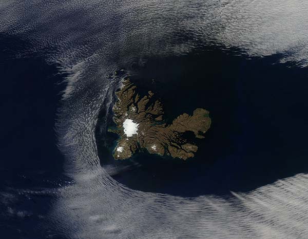
On February 20, 2016, the Moderate Resolution Imaging Spectroradiometer (MODIS) aboard NASA’s Aqua satellite flew over a remote location in the southern Indian Ocean and captured this rare true-color image of a portion of the Kerguelen Islands peeking out between the clouds.
The Kerguelen Islands sit approximately equidistant from Africa, Australia and Antarctica and are part of the French Southern and Antarctic Territories. Grande Terre is the largest island, and the one captured in this image. About 300 additional islands, islets and reefs make up the volcanic archipelago.
The weather on Grande Terre is notably bad. Located in the howling winds of the “furious fifties”, the island not only suffers incessant harsh wind, but a near-constant cloud cover brings rain or snow almost every day. The topography is nearly as harsh as the climate. Steep fjords line the coastal perimeter of the island, and the volcanic landscape’s ridges and valleys are sparsely covered by vegetation. Glaciers crawl across the rocky land, slowly grinding the underlying stone into a fine powder. The largest glacier is the Cook Ice Cap. Located in the western section of the island, this bright white, nearly circular feature is easily seen from space.
Despite the harsh conditions this island, as well as the other, smaller, islands in the Kerguelen chain, provide a haven for several species of wildlife, including dozens of species of birds. Penguins, elephant seals and fur seals also call the Kerguelen Islands home.
According to glaciologist Mauri Pelto, there is evidence that the glaciers on Grande Terre may be retreating. Writing in the American Geophysical Union’s Blogosphere on February 5, 2016, Dr. Pelto reports that a study comparing aerial images from 1963 and 2001 indicated that the 400 square kilometer ice cap had lost 21 percent of its area in the 38 year period. Another study also noted the appearance of a lake, Ampere Lake, at the main glacial termini of the Cook Ice Cap. The lake did not exist in 1963, but was present by 2006. A more recent image captured by Landsat in January of 2016 indicates the snowline appears similar to that reported in 2001.
Image Facts
Satellite:
Aqua
Date Acquired: 2/20/2016
Resolutions:
1km (35 KB), 500m (137.3 KB), 250m (336.4 KB)
Bands Used: 1,4,3
Image Credit:
Jeff Schmaltz, MODIS Land Rapid Response Team, NASA GSFC
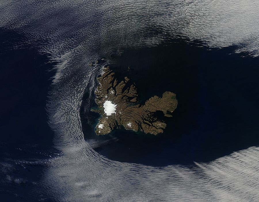
On February 20, 2016, the Moderate Resolution Imaging Spectroradiometer (MODIS) aboard NASA’s Aqua satellite flew over a remote location in the southern Indian Ocean and captured this rare true-color image of a portion of the Kerguelen Islands peeking out between the clouds. The Kerguelen Islands sit approximately equidistant from Africa, Australia and Antarctica and are part of the French Southern and Antarctic Territories. Grande Terre is the largest island, and the one captured in this image. About 300 additional islands, islets and reefs make up the volcanic archipelago.
The weather on Grande Terre is notably bad. Located in the howling winds of the “furious fifties”, the island not only suffers incessant harsh wind, but a near-constant cloud cover brings rain or snow almost every day. The topography is nearly as harsh as the climate. Steep fjords line the coastal perimeter of the island, and the volcanic landscape’s ridges and valleys are sparsely covered by vegetation. Glaciers crawl across the rocky land, slowly grinding the underlying stone into a fine powder. The largest glacier is the Cook Ice Cap. Located in the western section of the island, this bright white, nearly circular feature is easily seen from space.
Despite the harsh conditions this island, as well as the other, smaller, islands in the Kerguelen chain, provide a haven for several species of wildlife, including dozens of species of birds. Penguins, elephant seals and fur seals also call the Kerguelen Islands home.
According to glaciologist Mauri Pelto, there is evidence that the glaciers on Grande Terre may be retreating. Writing in the American Geophysical Union’s Blogosphere on February 5, 2016, Dr. Pelto reports that a study comparing aerial images from 1963 and 2001 indicated that the 400 square kilometer ice cap had lost 21 percent of its area in the 38 year period. Another study also noted the appearance of a lake, Ampere Lake, at the main glacial termini of the Cook Ice Cap. The lake did not exist in 1963, but was present by 2006. A more recent image captured by Landsat in January of 2016 indicates the snowline appears similar to that reported in 2001.
Image Facts
Satellite:
Aqua
Date Acquired: 2/20/2016
Resolutions:
1km (35 KB), 500m (137.3 KB), 250m (336.4 KB)
Bands Used: 1,4,3
Image Credit:
Jeff Schmaltz, MODIS Land Rapid Response Team, NASA GSFC
