Images
August 20, 2016 - Oil fires in Iraq
Tweet
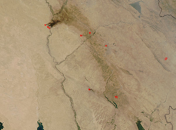
On August 17, 2016, NASA’s Aqua satellite passed over Iraq, allowing the Moderate Resolution Imaging Spectroradiometer (MODIS) flying aboard to capture a stark image of thick chocolate-brown smoke rising from red hotspots and blowing across Iraq’s Tigris River.
Smoke with this tar-like coloration is typical of burning oil fires, which have become all too common in oil-rich regions suffering violent conflicts. These fires cluster northwest of Al Qayyarh west of the Tigris River in an area where war rages as Iraqi Security Forces and an international Coalition (CJTR-OIH) attempt to retake the area from ISIL. In such conflict, oil facilities can become targets or be unintentionally damaged.
While news reports specific to the fires in this image are difficult to find, it was reported on August 10 that unknown armed men detonated an IED in an oil well in an oilfield about 40 miles northwest of Kirkuk, setting it on fire. That attack would have been east of this active fire. And on July 10 multiple media outlets reported that several Daesh (ISIL) militants set five oil wells south of Mosul on fire in an attempt to slow the advance of the government army. Those fires may be the ones seen in this image, but details of their exact location were not precise.
Other red hotspots, without accompanying smoke, can be seen in several locations throughout the image. It is difficult, based on this image alone, to discern the exact source of those heat signatures.
When crude oil burns, the smoke emitted has significant impact on health and the environment. Smoke is an irritant to human lungs, and can worsen asthma or other respiratory ailments. The combustion of fossil fuels release sulfur dioxide, nitrogen oxides, and carbon monoxide each of which is harmful to human heart, lungs and general health. Crude oil also contains various contaminants which may have a wide variety of damaging effects. In addition, when sulfur dioxide and nitrogen oxides combine with moisture in the air, acid rain is created. Acid rain is damaging to water (and organisms living in water), trees, vegetation, and soils.
Image Facts
Satellite:
Aqua
Date Acquired: 8/17/2016
Resolutions:
1km (29.1 KB), 500m (101.8 KB), 250m (251.5 KB)
Bands Used: 1,4,3
Image Credit:
Jeff Schmaltz, MODIS Land Rapid Response Team, NASA GSFC


