
Images


October 7, 2017 - Oceanic nonlinear internal solitary waves from the Lombok Strait
 Tweet
Tweet
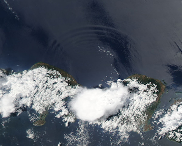
The rugged geography of the islands in Indonesia’s western volcanic arch, including narrow passages between islands, complex coastlines, and irregular underwater obstacles, creates significant impediments to the flow of water between the Pacific and Indian Oceans. In addition, the area experiences some of the strongest tidal flows on Earth - especially in the Lombok Strait, which lies between Bali and Lombok. The combination of complex geography, stratified water layers, and strong tidal flow make the Lombok Strait a favorable location for generation of intense internal waves.
Internal waves occur within the subsurface layers of the ocean where density stratification is strong, are generated where the interface between the layers of water is disturbed. The bottom of the Lombok Strait is complex and rough, with two main channels, one shallow and one deep. The movement of stratified water over this irregular bottom propagates strong and large internal waves which can be seen from space when conditions are right.
The best viewing of internal waves is in areas of “sunglint” - an optical effect caused by the mirror-like reflection of sunlight off the water surface directly back at the satellite sensor. Although sunglint washes out many features, it also reveals details about the water surface that are usually hidden from view. In this case, sunglint exposes the waves created by the movement of currents in the ocean water.
On October 5, 2017, the Moderate Resolution Imaging Spectroradiometer (MODIS) aboard NASA’s Aqua satellite flew over Indonesia and acquired a true-color image of oceanic nonlinear internal solitary waves from the Lombok Strait. Clouds hang over the islands of Bali and Lombok as well as the strait itself. Sunglint allows the viewing of the series of single, arching waves in the waters north of the islands.
Image Facts
Satellite:
Terra
Date Acquired: 10/29/2017
Resolutions:
1km (40.7 KB), 500m (85.1 KB), 250m (98.9 KB)
Bands Used: 1,4,3
Image Credit:
Jeff Schmaltz, MODIS Land Rapid Response Team, NASA GSFC
