Images
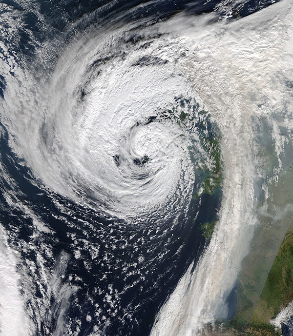
October 17, 2017 - Hurricane Ophelia (17L) over Ireland and Great Britain
Tweet
Hurricane Ophelia weakened and devolved into a post-tropical cyclone on the evening of October 15, 2017. However, the storm maintained enough strength to deliver destructive winds and rain to Ireland and the United Kingdom the next day. The Moderate Resolution Imaging Spectroradiometer (MODIS) on NASA’s Terra satellite captured this true-color image of Ophelia at 12:55 p.m. local time (11:55 Universal Time) on October 16, 2017.
Although Ophelia was no longer a hurricane when it passed over Ireland, wind gusts of over 100 mph (161 km/h). The highest gust was reported at 119 mph (192 km/h) off the coast of Cork at Fastnet Rock. This would beat the previous high-wind record for Ireland, which was 113 mph (182 km/h) when the island was battered by Hurricane Debbie in 1961.
According to the Irish Times, damage from Ophelia’s wind and rain was widespread, with the worst-affected areas in the south and the west. In Cork city, one of the stands in Turner’s Cross stadium collapsed, while in Kerry – where the center of the storm passed - thousands of residents were left without power from downed lines, while fallen trees blocked roadways. Three people died in Ireland due to the storm.
Image Facts
Satellite:
Terra
Date Acquired: 10/16/2017
Resolutions:
1km (1.3 MB), 500m (4.1 MB), 250m (10.3 MB)
Bands Used: 1,4,3
Image Credit:
Jeff Schmaltz, MODIS Land Rapid Response Team, NASA GSFC


