Images
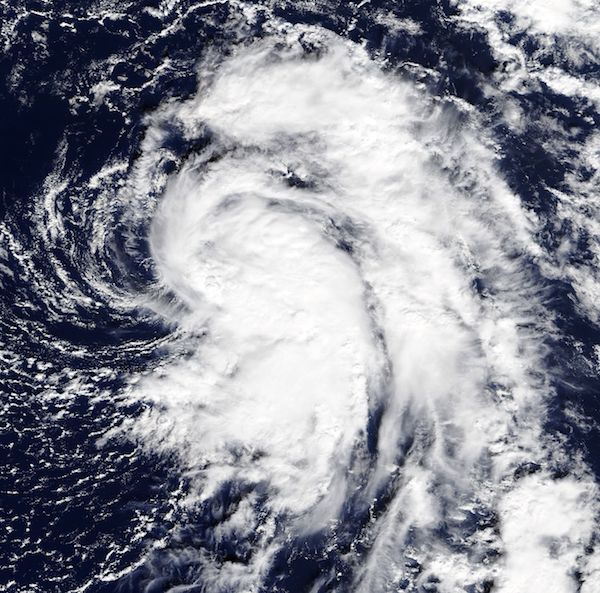
November 8, 2017 - Tropical Storm Rina
Tweet
Tropical Depression 19 strengthened into a tropical storm and was renamed Rina at 10 p.m. EST on November 6, 2017.
The Moderate Resolution Imaging Spectroradiometer (MODIS) aboard NASA’s Terra satellite acquired a true-color image of Tropical Storm Rina on that same day. The image showed that Rina's overall cloud pattern increased in coverage in the eastern quadrant of the storm.
By 4 a.m. EST (5 a.m. AST) on Tuesday, November 7 the center of Tropical Storm Rina was located near 31.4 degrees north latitude and 49.8 degrees west longitude. That's about 1,370 miles (2,200 km) west-southwest of the Azores islands. Rina was moving toward the north near 12 mph (19 km/h). This general motion accompanied by an increase in forward speed is expected through today. A turn toward north-northeast is forecast to occur by Wednesday night, November 8.
Maximum sustained winds are near 40 mph (65 km/h) with higher gusts. Some strengthening is forecast during the next 48 hours. The estimated minimum central pressure of 1009 millibars is based on recent reports from a nearby buoy. The National Hurricane Center (NHC) expects Rina to continue to accelerate toward the north today and then toward the north-northeast on Wednesday. By 48 hours, Rina is expected to get caught up in the mid-latitude westerlies and accelerate even more toward the northeast over the cold waters of the north Atlantic.
Image Facts
Satellite:
Terra
Date Acquired: 11/6/2017
Resolutions:
1km (129.6 KB), 500m (409.9 KB), 250m (1.1 MB)
Bands Used: 1,4,3
Image Credit:
Jeff Schmaltz, MODIS Land Rapid Response Team, NASA GSFC


