
Images


January 14, 2018 - Eruption of Kadovar, Papua New Guinea
 Tweet
Tweet
A surprise eruption of a dormant volcano shook the small island of Kadovar, Papua New Guinea on January 5, 2018. The steep-sided, tiny island is the 2 km (1.25 mi)-wide peak of a stratovolcano which lies at the western end of the 1000 km (621 mi) long Bismarck volcanic arc. There have been no eruptions at this site in recorded history, although increased thermal activity was reported in 1976 and 1981. As the volcano was erupting, the Rabaul Volcanological Observatory (RVO) warned of potential explosive activity, landslides, and potential tsunamis from the activity.
Dark gray ash and steam plumes rose from the southeast side of the island, according to a report by the Smithsonian Institution’s Global Volcanism Program. The report also stated that it was estimated that up to 60% of the island was covered in volcanic products, which primarily appeared to be ash along with some pyroclastic flows. Ashfall was also reported on Kairiru and Mushu islands, Mt. Uru in Yangoru, and Woginara, along with locations along the west coast of the Wewak District.
Although initial news reports regarding the population and evacuation status were unclear, the East Sepik Governor, Allan Bird, told media on 8 January that 591 residents of Kadovar had been evacuated to Blup Blup Island (about 10 km north) due to the organizational efforts of village councilors on the two islands.
RVO stated that during 7-8 January ash continued to be emitted, and blown tens of kilometers WNW. The Volcanic Ash Advisory Center Darwin (VAAC) has been monitoring the eruption, and reported significant ash through January 8 after which heavy cloud cover made monitoring difficult. Light ash and steam blowing to the northwest through cloud cover was reported on January 11. The VAAC issued their last report on the eruption on January 13.
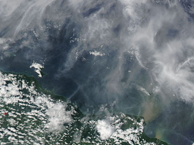
The Moderate Resolution Imaging Spectroradiometer (MODIS) aboard NASA’s Aqua satellite acquired a true-color image of the ongoing eruption of the Kadovar volcano on January 11. The cloud cover is complex and makes locating the ash plume somewhat difficult. Kadovar Island sits in the lower right section of the image (southeast) and just north of the prominent green protrusion of Papua New Guinea where the sediment of the Sepik River pours into the Bismarck Sea. While the island itself is obscured from view, a distinct plume of gray ash rises from a point source (the volcano) and blows to the northeast.
Image Facts
Satellite:
Aqua
Date Acquired: 1/11/2018
Resolutions:
1km (30.6 KB), 500m (49.4 KB), 250m (72.6 KB)
Bands Used: 1,4,3
Image Credit:
Jeff Schmaltz, MODIS Land Rapid Response Team, NASA GSFC
A surprise eruption of a dormant volcano shook the small island of Kadovar, Papua New Guinea on January 5, 2018. The steep-sided, tiny island is the 2 km (1.25 mi)-wide peak of a stratovolcano which lies at the western end of the 1000 km (621 mi) long Bismarck volcanic arc. There have been no eruptions at this site in recorded history, although increased thermal activity was reported in 1976 and 1981. As the volcano was erupting, the Rabaul Volcanological Observatory (RVO) warned of potential explosive activity, landslides, and potential tsunamis from the activity.
Dark gray ash and steam plumes rose from the southeast side of the island, according to a report by the Smithsonian Institution’s Global Volcanism Program. The report also stated that it was estimated that up to 60% of the island was covered in volcanic products, which primarily appeared to be ash along with some pyroclastic flows. Ashfall was also reported on Kairiru and Mushu islands, Mt. Uru in Yangoru, and Woginara, along with locations along the west coast of the Wewak District.
Although initial news reports regarding the population and evacuation status were unclear, the East Sepik Governor, Allan Bird, told media on 8 January that 591 residents of Kadovar had been evacuated to Blup Blup Island (about 10 km north) due to the organizational efforts of village councilors on the two islands.
RVO stated that during 7-8 January ash continued to be emitted, and blown tens of kilometers WNW. The Volcanic Ash Advisory Center Darwin (VAAC) has been monitoring the eruption, and reported significant ash through January 8 after which heavy cloud cover made monitoring difficult. Light ash and steam blowing to the northwest through cloud cover was reported on January 11. The VAAC issued their last report on the eruption on January 13.
The Moderate Resolution Imaging Spectroradiometer (MODIS) aboard NASA’s Aqua satellite acquired a true-color image of the ongoing eruption of the Kadovar volcano on January 11. The cloud cover is complex and makes locating the ash plume somewhat difficult. Kadovar Island sits in the lower right section of the image (southeast) and just north of the prominent green protrusion of Papua New Guinea where the sediment of the Sepik River pours into the Bismarck Sea. While the island itself is obscured from view, a distinct plume of gray ash rises from a point source (the volcano) and blows to the northeast.
Image Facts
Satellite:
Aqua
Date Acquired: 1/11/2018
Resolutions:
1km (30.6 KB), 500m (49.4 KB), 250m (72.6 KB)
Bands Used: 1,4,3
Image Credit:
Jeff Schmaltz, MODIS Land Rapid Response Team, NASA GSFC
