
Images


January 22, 2018 - Ship tracks off Spain
 Tweet
Tweet
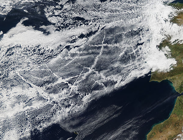
Ships traveling over the North Atlantic Ocean created a criss-crossed checkerboard in the clouds off the coast of Spain in mid-January 2018. The Moderate Resolution Imaging Spectroradiometer (MODIS) aboard NASA’s Aqua satellite acquired a true-color image of the scene on January 16.
Ship tracks form when very small, airborne particles emitted in the exhaust of large ships (and airplanes) attract water molecules, acting as “seeds” for clouds. These seeds are called cloud condensation nuclei. Continued accumulation of droplets on the cloud condensation nuclei forms the thin, streaky clouds pictured in these images. As the ships moved about the North Atlantic, they left a visible, though impermanent, record of where they have recently been. Generally speaking, the faster the ship, the narrower, longer, and less diffuse the ship track will be. Slower ships will leave shorter, wider, and more diffuse ship tracks. Ship tracks often reflect the direction and speed of the wind as much as the direction and speed of the ship.
Image Facts
Satellite:
Aqua
Date Acquired: 1/16/2018
Resolutions:
1km (835.2 KB), 500m (2.8 MB), 250m (6.9 MB)
Bands Used: 1,4,3
Image Credit:
Jeff Schmaltz, MODIS Land Rapid Response Team, NASA GSFC
