Images
August 16, 2019 - Foxe Basin
Tweet
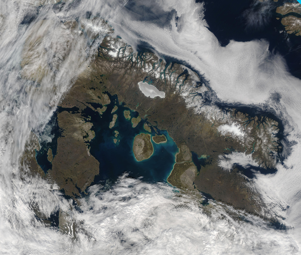
The broad, shallow Foxe Basin sits north of Hudson Bay in Nunavut, Canada, bounded by Baffin Island in the north and Southampton Island in the southeast. Ice covers the basin most of the year, with open pack-ice common in summer, and not melting until September, but the ice-free dates have been trending earlier in recent years. As ice melts and daylight lengthened, the nutrient-rich waters spur the growth of phytoplankton—small, plant-like organisms that live these cool waters year-round and can reproduce explosively when conditions are right.
On August 11, 2019, the Moderate Resolution Imaging Spectroradiometer (MODIS) on board NASA’s Aqua satellite acquired a true-color image of an ice-free Foxe Basin. Aqua and teal-toned colors swirl in the waters, particularly near the large, round Prince Charles Island and the smaller Air Force Island nearby.
Also visible is Baffin Island’s bright white Barnes Ice Cap, a remnant of the Laurentide Ice Sheet that covered much of North America during the Pleistocene Age. After existing for more than 2.5 million years, this ice cap now is shrinking rapidly, losing about 1 food of height each year at the highest elevations, and nearly 3 feet per year at the margins. A large bank of fog sits over the waters of the Davis Strait, hugging the northern coast of Baffin Island.
Image Facts
Satellite:
Aqua
Date Acquired: 8/11/2019
Resolutions:
1km (1.2 MB), 500m (4.2 MB), 250m (12.8 MB)
Bands Used: 1,4,3
Image Credit:
MODIS Land Rapid Response Team, NASA GSFC


