
Images


August 21, 2019 - Volga River Delta
 Tweet
Tweet
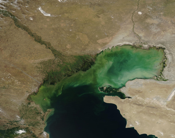
The Volga River Delta, the largest inland river delta in Europe, spreads about 100 miles (160 km) across southern Russia and, in the east, crosses the border with Kazakhstan. The mighty Volga River rises northwest of Moscow and flows about 2,175 miles (3,500 km) before emptying into the northern part of the Caspian Sea near the city of Astrakhan.
Over the past century, the Volga Delta has grown from 3,222 square kilometers (1,244 square miles) in 1880 to 27,224 square kilometers (10,511 square miles) in 2018. This significant growth is due both to sea level changes in the Caspian and the broad, gentle slope of the delta. When water from the river enters the delta, it gets split up into hundreds of waterways, creating one of the world’s most complicated hydrographic networks.
The delta is composed of three distinct zones. The first and most prominent includes the higher areas of the delta, which are dominated by very large linear mounds and basins. The second has very low relief and is the site of active and abandoned water channels which approach the coast of the Caspian Sea. The third zone a large, broad submerged platform that extends 20 to 40 miles (30-60 km) offshore.
Large volumes of sediment and nutrient-laden water pour from the Volga River, first through the muddy channels and then across the shallow platform, where they stir additional sediment in the Caspian Sea. This outpouring of warm, fresh, nutrient-rich water spurs the growth of phytoplankton (microscopic plant-like organisms) in the saline Sea. The growth of phytoplankton, along with suspended, swirling sediment, is responsible for the rich colors seen in the Caspian.
On August 18, 2019, the Moderate Resolution Imaging Spectroradiometer (MODIS) on board NASA’s Aqua satellite acquired a true-color image of the green Volga River Delta as it carries water into the brightly-colored northern Caspian Sea.
Image Facts
Satellite:
Aqua
Date Acquired: 8/16/2019
Resolutions:
1km (463.3 KB), 500m (1.2 MB), 250m (849.7 KB)
Bands Used: 1,4,3
Image Credit:
MODIS Land Rapid Response Team, NASA GSFC
