
Images


October 10, 2019 - Lake Athabasca, Canada
 Tweet
Tweet
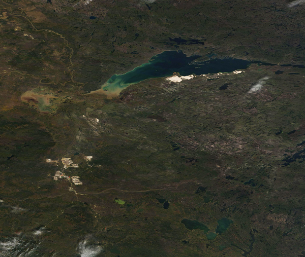
The eighth largest lake in Canada, Lake Athabasca straddles Alberta (west) and Saskatchewan (east) and covers an area of 7,935 square km (3,064 sq. mi). About 70 percent of the waters sit in Saskatchewan and the remaining 30 percent in Alberta. According to The Canadian Encyclopedia, the name Athabasca comes from the Cree word for the lake, athapiscow, describing an open area (such as a lake or swamp) where reeds, willows and grasses grow.
The area has been home to the Cree, Beaver and Chipewyan First Nations for more than 2,000 years.
Fort Chipewyan, the center of early fur trade, was established in 1788. The lake has provided a thriving commercial fishery since 1926 and, near the lake, mining for uranium and gold, as well as oil sands, have provided profits in more recent times.
In the southwestern end of the lake, the waters from the Athabasca and Peace Rivers flow into Athabasca while the major outflow is the northward-flowing Slave River. The Peace-Athabasca Delta, which spans 3900 sq. km (1,506 sq. mi) sits along the southwestern and southern shores of the lake. It is one of the largest inland freshwater deltas in the world. About 80% of the delta is located within Wood Buffalo National Park, a World Heritage Site and it also has been designated at a Ramsar site. It is ecologically important as a nesting and staging area for migratory waterfowl from all four North American flyways.
On October 12, 2019, the Moderate Resolution Imaging Spectroradiometer (MODIS) on board NASA’s Terra satellite acquired a true-color image centered on Lake Athabasca. Sediment stains the water tan near the Peace-Athabasca delta. The bright white areas near the southeastern shore mark the Lake Athabasca Sand Dunes, the largest active dunes in the world north of 58°. In 1992 they were protected as a Provincial Wilderness Park.
Image Facts
Satellite:
Terra
Date Acquired: 10/12/2019
Resolutions:
1km (363.3 KB), 500m (1006.7 KB), 250m (2.1 MB)
Bands Used: 1,4,3
Image Credit:
MODIS Land Rapid Response Team, NASA GSFC
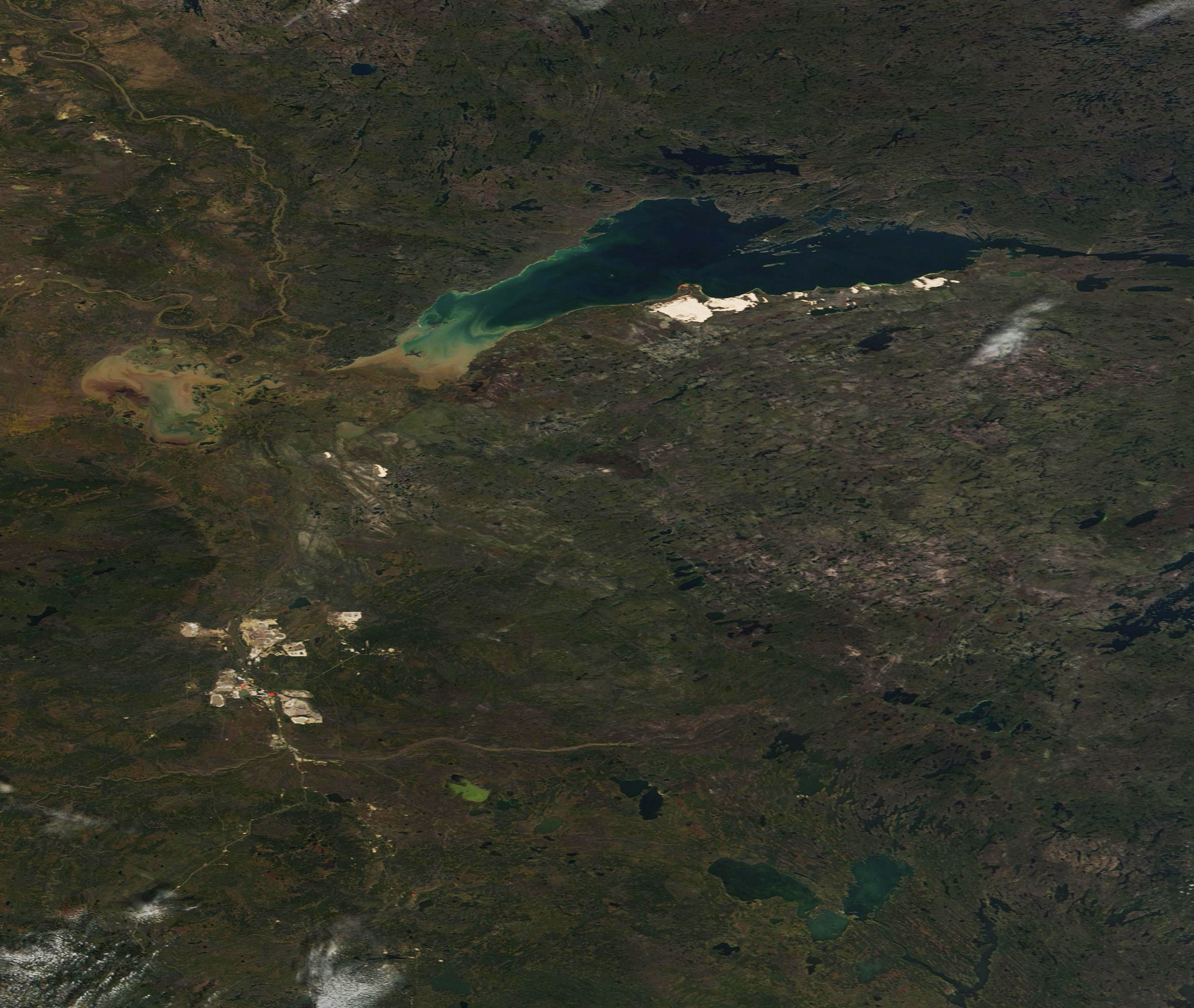
The eighth largest lake in Canada, Lake Athabasca straddles Alberta (west) and Saskatchewan (east) and covers an area of 7,935 square km (3,064 sq. mi). About 70 percent of the waters sit in Saskatchewan and the remaining 30 percent in Alberta. According to The Canadian Encyclopedia, the name Athabasca comes from the Cree word for the lake, athapiscow, describing an open area (such as a lake or swamp) where reeds, willows and grasses grow.
The area has been home to the Cree, Beaver and Chipewyan First Nations for more than 2,000 years. Fort Chipewyan, the center of early fur trade, was established in 1788. The lake has provided a thriving commercial fishery since 1926 and, near the lake, mining for uranium and gold, as well as oil sands, have provided profits in more recent times.
In the southwestern end of the lake, the waters from the Athabasca and Peace Rivers flow into Athabasca while the major outflow is the northward-flowing Slave River. The Peace-Athabasca Delta, which spans 3900 sq. km (1,506 sq. mi) sits along the southwestern and southern shores of the lake. It is one of the largest inland freshwater deltas in the world. About 80% of the delta is located within Wood Buffalo National Park, a World Heritage Site and it also has been designated at a Ramsar site. It is ecologically important as a nesting and staging area for migratory waterfowl from all four North American flyways.
On October 12, 2019, the Moderate Resolution Imaging Spectroradiometer (MODIS) on board NASA’s Terra satellite acquired a true-color image centered on Lake Athabasca. Sediment stains the water tan near the Peace-Athabasca delta. The bright white areas near the southeastern shore mark the Lake Athabasca Sand Dunes, the largest active dunes in the world north of 58°. In 1992 they were protected as a Provincial Wilderness Park.
Image Facts
Satellite:
Terra
Date Acquired: 10/12/2019
Resolutions:
1km (363.3 KB), 500m (1006.7 KB), 250m (2.1 MB)
Bands Used: 1,4,3
Image Credit:
MODIS Land Rapid Response Team, NASA GSFC
