
Images


February 15, 2020 - Massive Dust Storm off Africa
 Tweet
Tweet
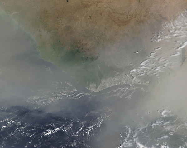
A massive cloud of dust blew off of Western Africa in mid-February, 2020, darkening the skies over most of the thousands of miles coastline between Gabon and Morocco with a thick tan haze. On February 14, the Moderate Resolution Imaging Spectroradiometer (MODIS) on board NASA’s Terra satellite acquired a true-color image of some of the thickest dust, which completely obscured the view of parts of Ghana, Togo, and Benin as it poured over the Atlantic Ocean.
As expansive as the storm appears in this image, it takes a wider view to gain a real perspective of the utterly massive movement of dust from the Sahara Desert. Thanks to the NASA Worldview App, the entire scene can be viewed
HERE.
The Sahara Desert is a frequent source of dust storms, especially between November and April, when Harmattan trade winds blow across the region, carrying vast amounts of mineral dust across West African skies. It has been estimated that hundreds of millions of tons of dust are picked up from the deserts of Africa and blow across the Atlantic Ocean each year. African dust can ride high in the atmosphere to reach the United States, the Caribbean, and even the Amazon, affecting air quality and depositing minerals to the soil.
The NASA Worldview app provides a satellite's perspective of the planet as it looks today and as it has in the past through daily satellite images. Worldview is part of NASA’s Earth Observing System Data and Information System. EOSDIS makes the agency's large repository of data accessible and freely available to the public.
Image Facts
Satellite:
Terra
Date Acquired: 2/14/2020
Resolutions:
1km (1.5 MB), 500m (4.4 MB), 250m (3.1 MB)
Bands Used: 1,4,3
Image Credit:
MODIS Land Rapid Response Team, NASA GSFC
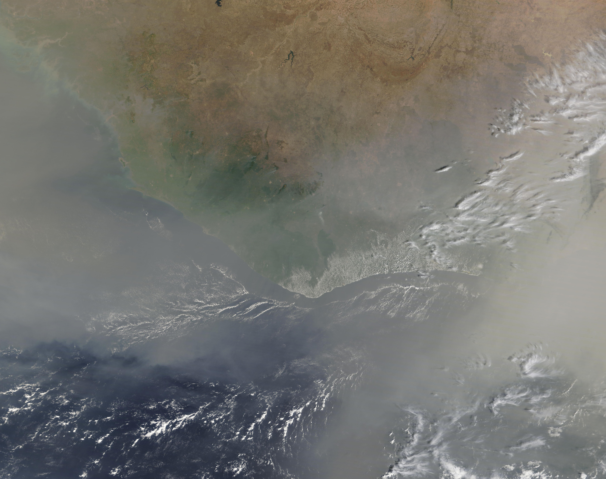
A massive cloud of dust blew off of Western Africa in mid-February, 2020, darkening the skies over most of the thousands of miles coastline between Gabon and Morocco with a thick tan haze. On February 14, the Moderate Resolution Imaging Spectroradiometer (MODIS) on board NASA’s Terra satellite acquired a true-color image of some of the thickest dust, which completely obscured the view of parts of Ghana, Togo, and Benin as it poured over the Atlantic Ocean.
As expansive as the storm appears in this image, it takes a wider view to gain a real perspective of the utterly massive movement of dust from the Sahara Desert. Thanks to the NASA Worldview App, the entire scene can be viewed HERE.
The Sahara Desert is a frequent source of dust storms, especially between November and April, when Harmattan trade winds blow across the region, carrying vast amounts of mineral dust across West African skies. It has been estimated that hundreds of millions of tons of dust are picked up from the deserts of Africa and blow across the Atlantic Ocean each year. African dust can ride high in the atmosphere to reach the United States, the Caribbean, and even the Amazon, affecting air quality and depositing minerals to the soil.
The NASA Worldview app provides a satellite's perspective of the planet as it looks today and as it has in the past through daily satellite images. Worldview is part of NASA’s Earth Observing System Data and Information System. EOSDIS makes the agency's large repository of data accessible and freely available to the public.
Image Facts
Satellite:
Terra
Date Acquired: 2/14/2020
Resolutions:
1km (1.5 MB), 500m (4.4 MB), 250m (3.1 MB)
Bands Used: 1,4,3
Image Credit:
MODIS Land Rapid Response Team, NASA GSFC
