Images
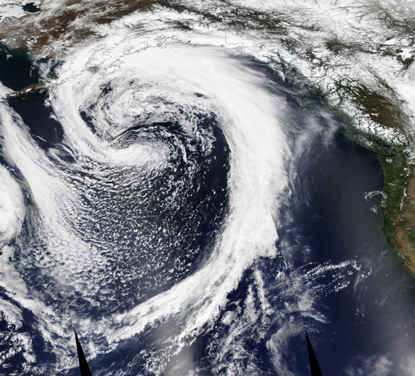
May 9, 2020 - Low-Pressure System off North America
Tweet
On May 7, 2020, a large low-pressure system sat off the coast of Alaska, bringing with it gale force winds and sea swells reaching 12 to 18 feet. According to the National Weather Service’s (NWS) Southeast Alaska Forecast Discussion on May 8, “Satellite imagery is dominated by low pressure over the far southwestern gulf and a large occluded front wrapped around it, stretching across the central gulf. This low and front are causing the only marine hazards in our area of responsibility.” The NWS predicted that the winds and high seas will slowly subside through May 9 as the low weakens and shifts off to the south.
The Moderate Resolution Imaging Spectroradiometer (MODIS) on board NASA’s Terra satellite acquired a true-color image of the low-pressure system on May 7 as the system stretched across parts of the the Gulf of Alaska and the Pacific Ocean. The low atmospheric pressure in the system has caused clouds and air to swirl around the center.
In the northern hemisphere, winds rotate around a low-pressure system in a counter-clockwise direction while in the southern hemisphere the rotation is clockwise. In meteorological terms, any low-pressure system may earn the term “cyclone”. A weak low-pressure system that develops along a weather front, such as this one, can also be called a “mid-latitude cyclone” or a “frontal cyclone”. Although they can bring difficult weather, with gusty winds, clouds and sea swells, these types of cyclones are rarely as intense as a tropical cyclone. Tropical cyclones develop over tropical oceans and are usually accompanied by very intense low-pressure systems, commonly below 950 millibars, and characterized by high wind speeds, intense storm surge, and high ocean waves.
Image Facts
Satellite:
Terra
Date Acquired: 5/7/2020
Resolutions:
1km (3.7 MB),
Bands Used: 1,4,3
Image Credit:
MODIS Land Rapid Response Team, NASA GSFC


