
Images


March 30, 2021 - Wildfires in Coahuila and Nuevo León, Mexico
 Tweet
Tweet
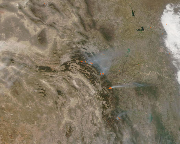
Springtime brings sunshine, warmth, and gusty winds to many parts of Mexico—add spring storms with lightning striking dry timberland and you have the perfect set-up for wildfire ignition and spread. March through May is fire season across much of Mexico, and the 2021 fire season is off to a robust start.
On March 25, the United Nations Office for the Coordination of Humanitarian Affairs (OCHA) reported on Relief Web that national authorities in Mexico stated that as of 24 March, there were 61 active forest fires across 20 States of Mexico, that have burnt an area of approximately 14,160 hectares. Fires in Coahuila and Nuevo León had damaged 80 houses and displaced 400 people. Local media reported that at least twelve of the fires were located in eight protected natural areas, including the Cumbres de Monterrey National Park in Nuevo León and in Coahuila in the municipality of Arteaga.
On March 26, 2021, the Moderate Resolution Imaging Spectroradiometer (MODIS) on board NASA’s Terra satellite acquired a true-color image of several fires burning in Coahuila and Nuevo León States, just south of the city of Monterrey in northeastern Mexico. Each red area marks a “hot spot” where the thermal bands on the MODIS instrument detected high temperatures. When combined with typical smoke, such as in this image, such hot spots mark actively burning fire. At least eight clusters of hot spots (active fires) were visible in the forested region, with smoke blowing strongly to the northeast.
An article by Wildfire Today, published online on March 28, stated that a DC-10 air tanker started a contract with the state of Coahuila to assist firefighters battling a fire 20 miles of southwest of Monterrey. Although grounded due to weather on March 28, the aircraft was prepared to assist as soon as weather permitted. They will be working and reloading out of an airport in Laredo, Texas located about 160 miles (260 km) northeast of the fire. On that date, the size of the fire to be fought appeared to be “several thousand acres” in size, while a fire about 4 miles (6.5 km) to the east appeared to be cover about 22,000 acres.
Image Facts
Satellite:
Terra
Date Acquired: 3/26/2021
Resolutions:
1km (31.1 KB), 500m (103.3 KB), 250m (304.3 KB)
Bands Used: 1,4,3
Image Credit:
MODIS Land Rapid Response Team, NASA GSFC
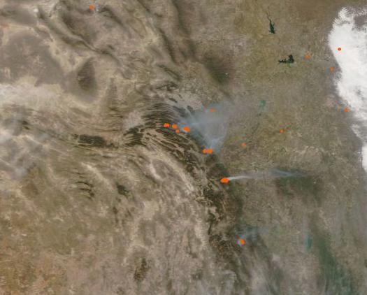
