Images
July 11, 2021 - Color in the Sea of Azov
Tweet
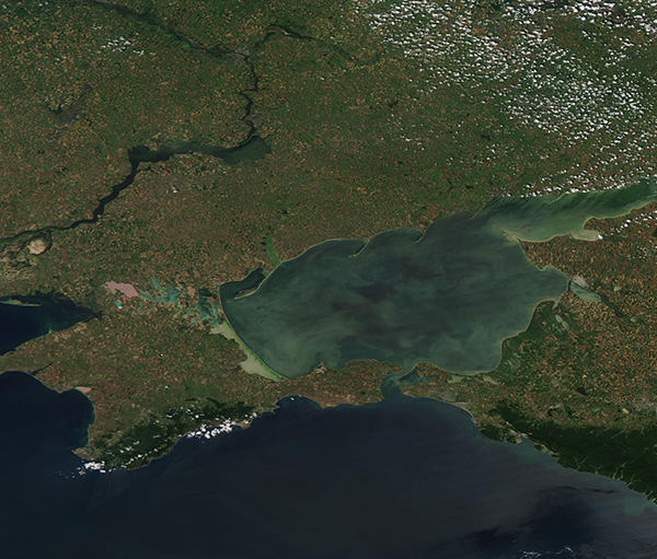
Swirls of tan and green colored the waters of the Sea of Azov in early July 2021. The Moderate Resolution Imaging Spectroradiometer (MODIS) on board NASA’s Aqua satellite acquired a true-color image of the colorful scene on July 9.
With depth ranging between 3 feet (0.9 m) and 46 feet (14 m) and an average depth of 23 feet (7 m), The Sea of Azov is considered the shallowest sea in the world. It is located in the south of Eastern Europe, flanked by the Ukraine in the north, Russia to the east, the Black Sea in the south and the Crimean Peninsula in the west.
Saline water flows into the Sea of Azov from the Black Sea through the narrow Kerch Strait and fresh water pours in from several rivers, especially the large Don River and the Kuban River. It can be considered a sort of mixing bowl, with fresh water keeping salinity lower than sea water, stirring up sediment, and encouraging growth of phytoplankton. These microscopic plant-like organisms form the base of the food marine food web, providing plentiful food for a wide variety of fish that live in the Sea of Azov. Because they contain chlorophyl, a green pigment that is essential in photosynthesis, large masses of phytoplankton floating on water appear green from space. Suspended sediment—whether carried in from rivers, washed into the Sea from land, or churned up from the bottom by wind and wave—appears tan in satellite images. It is likely that the color in the Sea of Azov comes from a combination of phytoplankton and sediment.
Image Facts
Satellite:
Aqua
Date Acquired: 7/9/2021
Resolutions:
1km (474.5 KB), 500m (1.1 MB), 250m (798.9 KB)
Bands Used: 1,4,3
Image Credit:
MODIS Land Rapid Response Team, NASA GSFC


