
Images


August 20, 2021 - Hurricane Grace west of Grand Cayman
 Tweet
Tweet
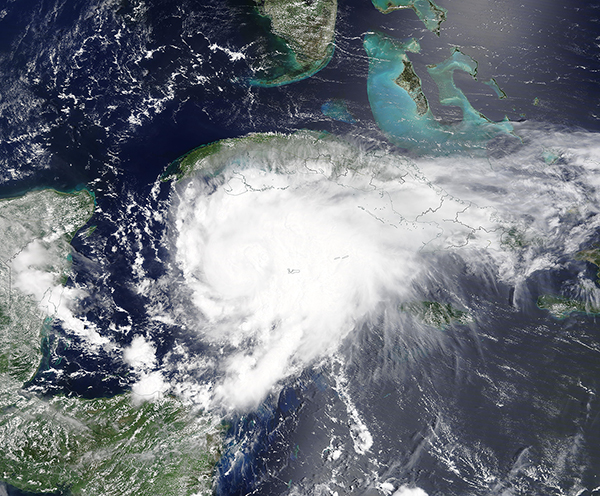
On August 18, 2021, the Moderate Resolution Imaging Spectroradiometer (MODIS) on board NASA’s Terra satellite captured a true-color image of Hurricane Grace taking aim at Mexico’s Yucatan Peninsula. In this image, Grace sports a cloud-filled center of circulation with Grand Cayman dwarfed just to the east of the distinct center. Convective bands reach over southern Cuba, bringing rain and wind to that island. The green tip of the Yucatan Peninsula sits just to the west of Hurricane Grace.
Grace became a tropical storm on August 14 about 420 miles (675 km) east of the Leeward Islands. After charging through the Caribbean as a drenching tropical storm—including dropping 13.6 inches (34.5 cm) on Kingston, Jamaica and a similar amount on earthquake-damaged Haiti—Grace strengthened to hurricane strength at just west of Grand Cayman, according to the National Hurricane Center (NHC). At 11:00 a.m. EDT (1500 UTC) on August 18, the NHC advised that Hurricane Grace was located about 65 mi (105 km) west of Grand Cayman. At that time, Grace carried maximum sustained winds of 75 mph (120 km/h) and was moving west-northwest at 15 mph (24 km/h), which headed it towards Mexico’s Yucatan Peninsula.
At 5:50 a.m. EDT (0945 UTC) on August 19, Hurricane Grace made landfall along the eastern Yucatan Peninsula about 10 miles (15 km) south of Tulum. At least one news service reported that this was south of the ancient Mayan temples located near that city. The NHC advised that Hurricane Grace was carrying maximum sustained winds of 80 mph (130 km/h) at that time, with gusts measured as high as 85 mph (137 km/h) near Playa del Carmen, Mexico. After striking land, Grace quickly weakened to tropical storm strength, with winds falling below 75 mph (120 km/h). Early reports suggest that the popular tourist region has seen no major damage from the storm.
At 11:00 p.m. EDT on August 19 (0300 UTC on August 20), the NHC advised that Tropical Storm Grace had crossed the Yucatan Peninsula and was beginning to intensify as it crosses the southwestern Gulf of Mexico. Grace was carrying maximum sustained winds of 65 mph (100 km/h) and was moving west at 16 mph (26 km/h). The center of the storm was located about 105 miles (170 km) northwest of Campeche, Mexico and 360 mi (580 km) east of Tuxpan, Mexico. Grace is expected to continue to move west to south-westward to make landfall on the mainland coast of Mexico on the evening or night of August 20. Given the warm sea surface temperatures of the Gulf of Mexico and favorable environment, it is likely that Grace will regain hurricane strength before landfall.
Image Facts
Satellite:
Terra
Date Acquired: 8/18/2021
Resolutions:
1km (2.5 MB), 500m (7.3 MB), 250m (5.3 MB)
Bands Used: 1,4,3
Image Credit:
MODIS Land Rapid Response Team, NASA GSFC
